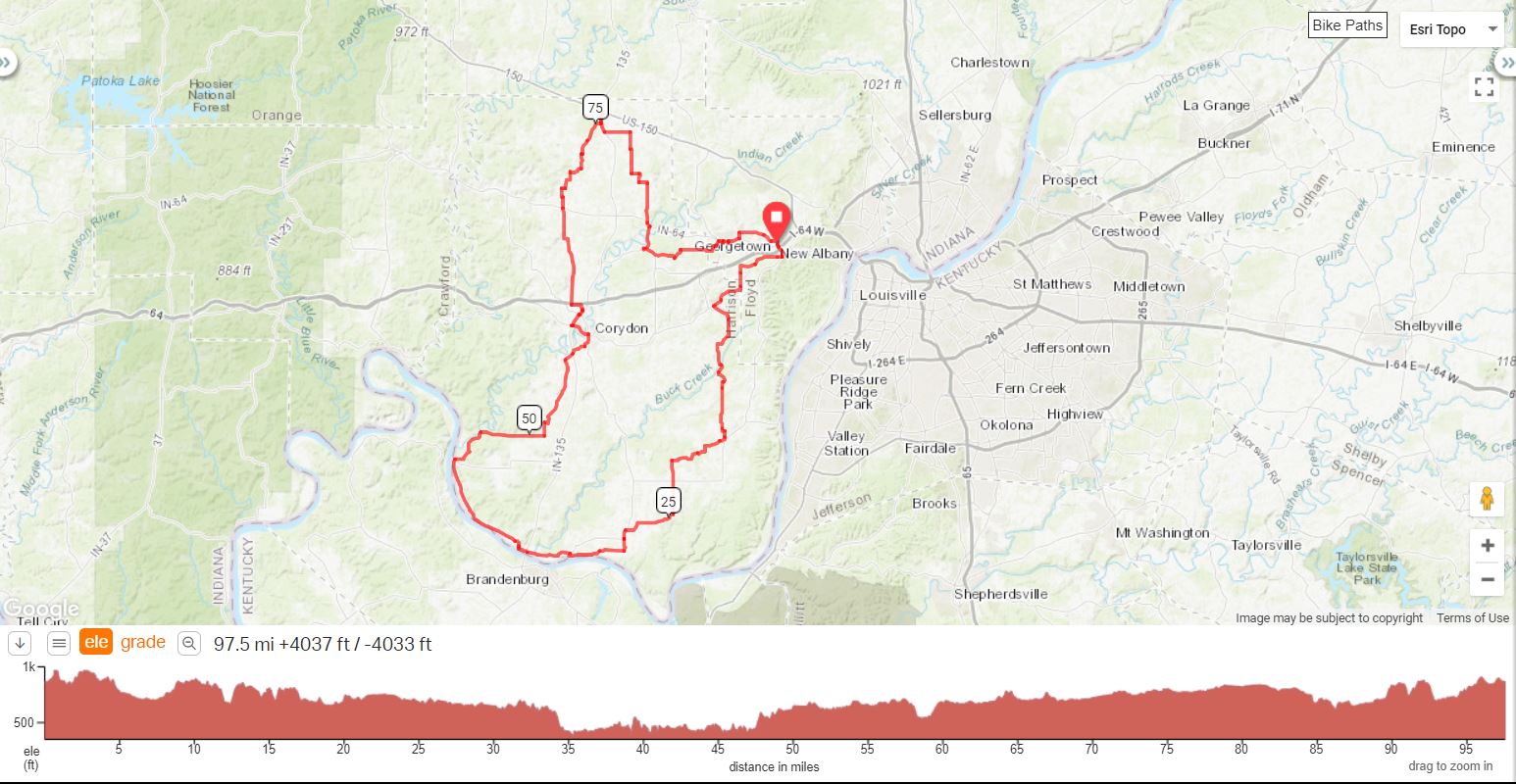
Click link for Google Maps navigation to the the start.
Marathon Parking Lot
1046 N Luther Rd
Georgetown, IN 47122
The Harrison |
||
0.0 |
L |
North Luther Rd |
0.1 |
R |
Onto West Knable Rd |
0.2 |
L |
Hwy IN 64 |
0.9 |
R |
Corydon Ridge Rd |
3.6 |
L |
Old Salem Rd |
5.0 |
R |
Tandy Rd |
6.6 |
R |
Hwy 62 |
7.2 |
L |
St. Johns Church Rd |
12.2 |
R |
Bear right onto Black Creek Rd |
13.2 |
R |
Lotticks Corner Rd |
13.3 |
L |
Bear left to stay on Lotticks Corner Rd |
13.8 |
S |
Becomes 7 Springs Rd |
16.4 |
L |
Elizabeth New Middletown Rd |
16.6 |
R |
Main St. |
16.9 |
Alt. Store Stop-Wilson's, L on Beech St. |
|
17.1 |
R |
Rogers Campground Rd |
19.2 |
L |
To stay on Rogers Campground Rd. |
21.1 |
L |
Pumping Station Rd |
22.4 |
S |
N. Rehobeth Rd |
24.0 |
L |
Hooptown Rd |
24.4 |
R |
To stay on Hooptown Rd (no sign) |
28.0 |
L |
Hwy 11 |
28.5 |
R |
Cross St |
28.5 |
Store Stop - Laconia General Store |
|
28.5 |
R |
N Tobacco Landing Rd |
29.3 |
R |
Scenic View Drive |
31.0 |
L |
To stay on Scenic View Drive |
33.2 |
L |
Hwy 11 |
36.1 |
S |
Becomes 2nd St |
36.6 |
R |
Beech St. (last street) |
36.8 |
L |
4th St |
36.9 |
S |
Becomes River Rd |
44.1 |
R |
Main St (becomes Blue Spring Rd) |
46.9 |
S |
Lickford Bridge Rd |
50.9 |
L |
Hill Grove Rd |
51.7 |
R |
Shiloh Rd |
55.5 |
L |
Green Acres Drive |
56.3 |
R |
Heidelberg Rd |
56.9 |
S |
Cross Hwy 135 |
57.9 |
L |
Old Hwy 135 |
58.8 |
L |
W Walnut St. |
60.0 |
S |
Cross Hwy 135 |
60.0 |
R |
Gardner Lane (bank entrance) |
60.9 |
R |
Hwy 337 |
60.9 |
L |
Edsel Lane (no sign, left B4 Hwy) |
61.1 |
S |
Lunch - Subway, DQ, Culvers |
61.2 |
L |
Federal Drive (at Culvers) |
61.6 |
L |
Pacer Court Northwest |
62.2 |
R |
Corydon Ramsey Rd |
68.4 |
S |
Cross Hwy 64 |
69.7 |
R |
Flatwood Rd |
69.9 |
L |
Buffalo Trace |
71.2 |
R |
To stay on Buffalo Trace |
72.0 |
L |
To stay on Buffalo Trace |
72.8 |
R |
Hancock Chapel Rd |
72.9 |
L |
Buffalo Trace |
73.9 |
R |
To stay on Buffalo Trace |
75.4 |
L |
Hwy 135 |
76.1 |
Store Stop - Sav-A-Step |
|
76.1 |
R |
Hwy 135 (reverse direction) |
77.4 |
L |
Old East Rd |
79.0 |
R |
Gettlefinger Rd |
80.0 |
L |
School Lane |
81.6 |
L |
Flatwood Rd |
82.1 |
R |
Farmers Lane |
82.6 |
L |
Nadorff Rd |
83.1 |
R |
Walk Drive |
85.6 |
L |
Hwy 64 |
85.8 |
R |
Hwy 335 |
87.4 |
L |
Crandall Lanesville Rd |
89.5 |
L |
Angel Run Rd |
90.2 |
R |
Old Lanesville Rd |
92.6 |
L |
Georgetown Lanesville Rd |
92.9 |
R |
Lois Lane (B4 RR Trestle) |
93.2 |
L |
Wissman Rd (no sign) |
93.3 |
R |
Walts Rd |
93.6 |
L |
C L Whitlock Way |
93.7 |
R |
Main St (Hwy 64) |
94.4 |
L |
Henriot Rd (after Marathon) |
94.8 |
R |
Frank Ott Rd |
96.3 |
S |
Edwardsville Galena Rd. |
96.9 |
S |
W Willis Rd |
97.2 |
R |
N Luther Rd |
97.5 |
End - Marathon Station |
|