| 1314
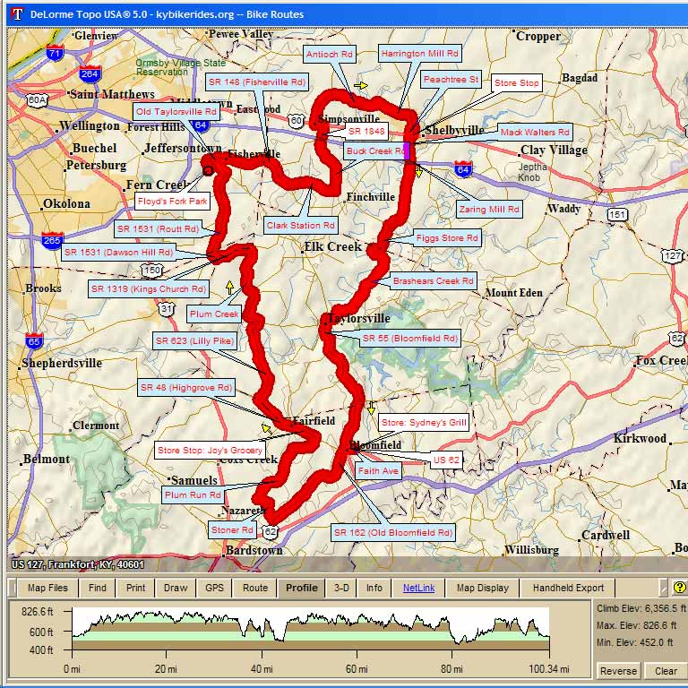
- Floyds Fork Park Century 99.1mi, Cumulative Climb: 6357 ft, avg: 64 ft/mile, Start Al. 545' Start: Floyd's Fork Park, Louisville, KY RC:Steve Rice |
||
| Miles | Turn | Road |
| 0.0 | L | S Pope Lick Rd |
| 0.4 | R | Old Taylorsville Rd |
| 1.9 | L | Fisherville Rd at Post Office |
| 2.0 | R | Hwy 148 |
| 6.9 | L | Clark Station Rd |
| 10.3 | L | Buck Creek Rd |
| 13.8 | BR | Becomes Veechdale Rd |
| 15.2 | L | US 60 |
| 15.8 | R | Todds Point Rd (1848) |
| 18.2 | R | Antioch Rd |
| 21.5 | L | Scott Station Rd |
| 21.9 | R | Harrington Mill Rd |
| 24.3 | R | Hwy 53 |
| 25.4 | R | Sanford Ln |
| 25.6 | L | Cardinal Dr |
| 25.9 | R | Cherry Ln |
| 26.0 | L | 2nd - becomes Peachtree |
| 26.1 | L | US60W |
| 26.2 | Store Stop. Leave Store heading West on US 60 | |
| 26.3 | R | Mack Walters / Zaring Mill (1st light) |
| 33.0 | R | Hwy 148 |
| 33.1 | QL | Figgs Store Road |
| 35.5 | L | Breashears Rd (Bottom of hill - go over bridge) |
| 37.3 | R | Brashears Creek Rd |
| 43.1 | L | Hwy 44 (Taylorsville) |
| 43.4 | R | Hwy 44 |
| 43.5 | L | Hwy 55 |
| 53.2 | L | US 62 |
| 53.8 | L | Arnold Lane |
| 53.9 | Lunch - Sydney's Grill. 155 Arnold Lane - 502-252-9997 | |
| 53.9 | Head South on Arnold lane towards US 62 | |
| 54.0 | R | US 62 |
| 54.6 | S | Hwy162 |
| 62.0 | R | Stoner Rd |
| 64.0 | R | Plum Run |
| 70.5 | L | Hwy48 |
| 72.3 | Store Stop Joy's Grocery Fairfield | |
| 72.3 | R | Hwy 48 |
| 75.2 | R | Hwy 623 |
| 81.3 | L | Turn left onto Hwy 44 |
| 82.1 | R | Turn right onto Ky-1060 |
| 87.3 | L | Hwy 1319 |
| 89.8 | R | Dawson Hill Rd |
| 90.2 | R | Routt Rd |
| 96.1 | L | Taylorsville Lake Rd |
| 97.3 | R | Hwy 148 |
| 97.5 | R | S English Station Rd |
| 97.7 | R | Old Taylorsville Rd |
| 98.7 | L | S Pope Lick Rd |
| 99.1 | Parking Lot | |
Map Images are copyright © 2004 Delorme, TOPO USA ® and are provided pursuant to their End User Licensing Agreement. Visit http://www.delorme.com for more information.