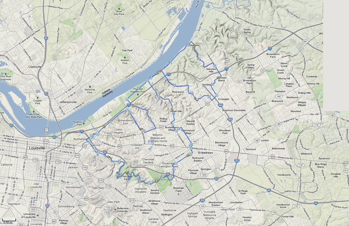
| Burdorf 27 Mile | ||
Miles |
Turn |
Road |
L |
Out of parking lot-St. Matthews Ave. |
|
0.05 |
R |
Westport Rd. |
0.06 |
L |
St. Matthews Ave. X RR Tracks |
0.8 |
L |
Napanee Rd. |
1.1 |
R |
Chenoweth Ln. |
1.4 |
X |
Hwy. 42-BUSY |
1.4 |
R |
Old Brownsboro Rd. |
1.6 |
L |
Indian Hill Trail |
3.7 |
R |
River Rd. |
5.9 |
R |
Glenview Ave. |
7.1 |
L |
Brittany Valley Rd. |
7.5 |
R |
Lime Kiln Rd. |
8.0 |
R |
Glenwood Rd. |
8.1 |
L |
Harwood Rd. |
8.6 |
L |
Northfield Dr. |
8.9 |
R |
Northfield Dr. |
9.0 |
R |
Hwy. 42-BUSY |
9.3 |
R |
Rudy Ln. |
9.5 |
L |
Apache Rd. |
10.0 |
R |
Blankenbaker Ln. |
12.1 |
L |
River Rd. |
13.8 |
L |
Mockingbird Valley Rd. |
15.5 |
R |
Hwy. 42-BUSY |
16.0 |
R |
Zorn Ave. |
17.1 |
L |
Mellwood Ave. |
18.6 |
R |
onto Brownsboro Rd./Story Ave. |
18.7 |
BL |
to stay on Story Ave. |
19.1 |
L |
Spring St. |
19.8 |
L |
Lexington Rd. |
20.8 |
X |
Grinstead Dr. |
21.0 |
R |
Ledges into Cherokee Park and up Dog Hill |
21.5 |
BL |
at top of Dog Hill |
21.8 |
BL |
Stay on Scenic Loop |
23.3 |
R |
Beargrass Rd. |
24.0 |
L |
Seneca Park Rd. |
24.3 |
R |
onto Seneca Park Path |
25.2 |
L |
Old Cannons Ln. |
25.4 |
L |
Huntington Rd. |
25.5 |
R |
Alden Rd. |
25.7 |
R |
Canterbury Ln. |
25.8 |
L |
Canterbury Ln. |
25.9 |
X |
Cross Cannons Ln. onto Nanz Ave. |
26.6 |
L |
Meridian Ave. |
26.6 |
R |
Willis Ave. |
26.7 |
X |
Breckenridge Ln. |
26.8 |
X |
Shelbyville Rd. |
26.8 |
L |
into Parking lot |