We originally enjoyed this ride with Max Limbocker of the Southern Indiana Cycling Club. This route is unchanged except for a few clarifications and corrections. Mappoint Link to Start
| 2900 - Scenic Sixty Memphis, IN, Bunker Hill, Scottsburg 56.2 mi, Cumulative Climb: 2998 ft, avg: 53 ft/mile Start: Memphis Truck Plaza, Memphis, IN. From I-65 take exit 16 and proceed east 1 block on Blue Lick Road. Truck stop is on North side of the road. |
||
| Miles | Turn | Road |
| 0.0 | R | Out of Memphis Truck Plaza |
| 0.0 | S | Blue |
| 2.8 | R | |
| 4.2 | Bear L | |
| 5.9 | L | SR 160 (Highway 160 W) |
| 11.0 | R | |
| 12.8 | R | S New |
| 17.0 | R | New Salem-Finley Knob |
| 18.2 | Bear R | |
| 19.3 | L | After Covered Bridge to stay on Leota |
| 22.7 | L | CR 100 W ( |
| 24.5 | R | West Lake Rd |
| 24.5 | Stop | Grocery-Restroom |
| 25.5 | X | US 31 |
| 25.7 | L | |
| 26.3 | Bear R | |
| 26.7 | R | Stop Sign W SR 56 ( Go around |
| 26.8 | R | |
| 26.9 | R | |
| 27.0 | L | |
| Stop | Great Restaurant | |
| R on |
||
| 29.5 | X | 356 (becomes Underwood Road) |
| 31.6 | L | CR 500 S ( |
| 32.4 | R | CR 150 (S Double Or
|
| 32.9 | Bear L | |
| 34.8 | Bear R | |
| 35.4 | R | |
| 36.7 | R | Beagle |
| 39.4 | R | To stay on |
| 40.2 | L | |
| 42.3 | X | Hebron Church Rd (Old State Rd becomes
|
| 43.4 | L | |
| 44.2 | Bear L | SR 160 (Highway 160 E) |
| 44.3 | R | Caney Rd |
| 44.9 | L | |
| 47.2 | S | Becomes |
| 49.2 | S | Down Hill to stay on |
| 49.9 | R | |
| 50.3 | S | |
| 50.5 | L | (unmarked) Court St after RR Tracks |
| 50.5 | X | 31 onto |
| 52.9 | R | |
| 53.6 | R | Crone Rd |
| 55.9 | R | Blue |
| 56.2 | L | Memphis Truck Plaza |
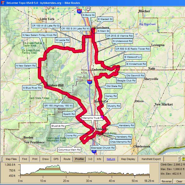
Map Images are copyright © 2006 Delorme, TOPO USA ® and are provided pursuant to their End User Licensing Agreement. Visit http://www.delorme.com for more information.