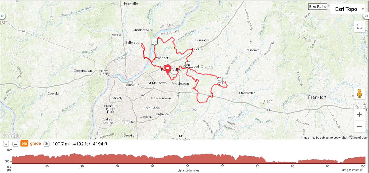
Suburbane Century -
100.7 miles |
||
MILES |
TURN |
ROAD |
0.0 |
R |
Freys Hills Rd |
0.9 |
L |
Evergreen Road |
1.0 |
R |
Evergreen Road |
2.0 |
L |
E Osage Rd |
2.5 |
BL |
E Osage Rd |
2.7 |
BL |
N Osage Rd |
3.1 |
R |
Lucas Ln |
3.7 |
L |
Old LaGrange Rd |
5.2 |
L |
Westport Rd |
5.7 |
R |
Rollington Rd |
6.9 |
R |
Rollington Road |
7.4 |
R |
Central Avenue, KY 362 |
7.9 |
L |
Central Avenue, KY 362 |
8.2 |
L |
Mt Mercy Dr at the Caboose |
8.4 |
X |
RR Tracks to Maple Ave |
8.9 |
L |
Cherry Ln |
10.0 |
R |
Turn right onto KY-1408 |
10.3 |
BL |
Old Floydsburg Rd |
10.4 |
BR |
KY-1408 |
13.2 |
BL |
KY-362 |
18.2 |
S |
Anderson Ln |
21.4 |
R |
Hebron Rd |
22.7 |
R |
Scott Station Rd |
23.0 |
R |
Scott Station-Antioch Rd |
26.3 |
L |
State Hwy 1848 |
28.8 |
L |
Midland Trail/Shelbyville Rd |
28.8 |
R |
Old Veechdale Rd |
29.1 |
L |
Rolling Ridge Way |
29.6 |
R |
Simpsonville-Buck Creek Rd |
29.9 |
R |
Front Gate Rd into Dairy Queen |
30.0 |
L |
Aristocrat Ct STORE STOP |
30.5 |
R |
State Hwy 1399 |
34.8 |
R |
KY-148 W |
35.5 |
R |
Old Clark Station Rd |
35.8 |
S |
Clark Station Rd |
37.2 |
R |
Clark Station Rd |
39.2 |
L |
Lacewood Way |
39.3 |
R |
Brightleaf Pl |
39.9 |
R |
Arlington Meadows Dr |
40.0 |
L |
Shelbyville Rd |
40.5 |
BR |
Shelbyville Rd |
40.5 |
R |
Long Run Rd |
43.1 |
L |
Long Run Park Rd |
43.2 |
R |
Long Run Park Rd- bathrooms on right before Flat Rock |
44.7 |
R |
Turn right onto Flat Rock Rd |
45.5 |
R |
Flat Rock Rd |
46.3 |
R |
KY-1531/Aiken Rd |
46.5 |
L |
KY-362 W |
48.7 |
R |
Hawley Gibson Rd |
50.2 |
BR |
Old Floydsburg Rd |
50.2 |
L |
KY-1408 |
51.3 |
R |
Hwy 22 |
51.5 |
L |
Dogwood Ln/W State Hwy 22 |
51.6 |
R |
Lagrange Rd |
51.9 |
R |
Into McDonald's STORE STOP |
51.9 |
L |
Lagrange Rd |
52.1 |
L |
Veterans Memorial Pkwy |
52.2 |
L |
Old Lagrange Rd |
55.6 |
S |
Take the pedestrian overpass |
56.7 |
L |
KY-146 W |
57.1 |
R |
Cedar Point Rd/New Cut Rd |
58.2 |
BL |
Old Zaring Rd |
60.3 |
R |
Glenarm Rd |
61.1 |
L |
KY-1817 |
61.7 |
R |
Hwy 329/Covered Bridge Rd |
62.0 |
R |
KY-1694 N |
67.0 |
L |
US-42 |
69.5 |
R |
Goshen Ln |
71.7 |
BR |
To stay on Goshen Ln |
72.3 |
BL |
N Rose Island Rd |
77.7 |
R |
US-42 |
78.3 |
R |
Greenmere Blvd |
78.4 |
L |
Windham Pkwy |
78.6 |
L |
Sedgwicke Dr |
78.8 |
L |
River Rd |
78.8 |
R |
Into parking lot and proceed to Dairy Queen STORE STOP |
79.1 |
L |
Heading towards hardware store |
79.1 |
BL |
Past hardware towards River Rd |
79.3 |
L |
River Rd |
80.4 |
R |
Lewis & Clark bridge path |
82.9 |
R |
Old Salem Rd |
83.5 |
S |
8th St |
85.7 |
L |
Paul Garrett Ave |
87.1 |
L |
Patrol Rd |
88.1 |
L |
River Ridge Pkwy |
89.0 |
R |
8th St |
90.9 |
S |
Old Salem Rd |
91.4 |
L |
Lewis & Clark bridge path |
93.9 |
R |
River Rd |
94.4 |
L |
Wolf Pen Branch Rd |
95.4 |
L |
Wolf Pen Branch Rd after crossing Hwy 42 |
95.6 |
R |
Springdale Rd |
98.3 |
S |
N Hurstbourne Pkwy |
98.5 |
L |
Springhurst Blvd |
99.5 |
X |
Westport Rd to Freys Hill Rd |
100.7 |
R |
Tom Sawyer Park |
Printer friendly Cue Sheet (pdf format)