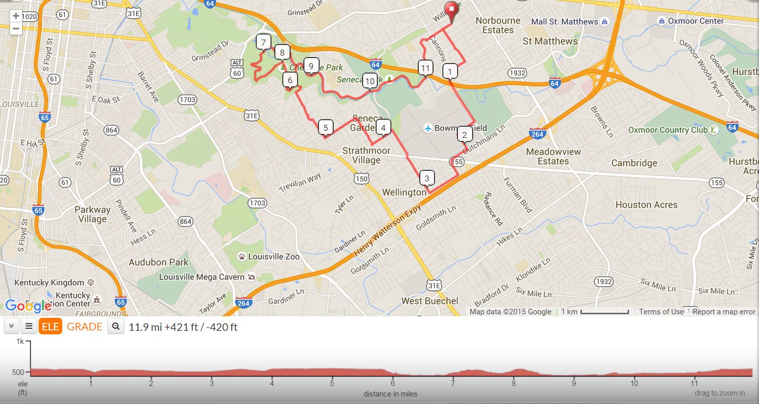
This is a variation of the traditional LBC Recovery Ride. It goes around the scenic loop in Cherokee Park and up Dog Hill instead of going out to Lexington Road and down Grinstead Drive.
Tags: City, Low Traffic Area, Residential Area, Rolling to flat, Scenic
Dog Hill Recovery Ride |
||
0 |
L |
Nanz Ave. |
0.2 |
L |
Iola Road |
0.8 |
R |
Winchester Rd. |
0.9 |
L |
Cannons Lane @ Light |
1.6 |
R |
Sidney Park Dr. |
1.8 |
L |
Gast Blvd. |
2.1 |
R |
Dutchmans Lane |
2.3 |
X |
Taylorsville Road |
S |
Becomes Betty Lane |
|
2.5 |
R |
Gardiner Lane |
2.9 |
R |
Bon Air Ave. |
3.5 |
X |
Taylorsville Road |
S |
Becomes Pee Wee Reese Rd. |
|
3.9 |
L |
Denham Road (Bottom of Hill) |
4.2 |
R |
Valetta Road |
4.5 |
L |
Woodbourne Ave. |
5 |
R |
Eleanor Ave |
5.3 |
L |
Village Drive (Stay on around circle) |
5.4 |
L |
Castleberry Road |
5.7 |
R |
Cherokee Road |
5.8 |
L |
Barrett Hill Rd. (Down Hill) |
6 |
R |
Scenic Loop (Bottom of Hill at Triangle) |
6.4 |
L |
Cherokee Park Road (Scenic Loop) |
6.7 |
L |
Cherokee Park Road (Scenic Loop) |
7.3 |
L |
At Top of Hill Stay on Scenic Loop |
7.6 |
L |
At Bottom of Hill Stay on Scenic Loop |
8 |
S |
Past Hogans Fountain on Scenic Loop |
8.4 |
L |
At bottom of Hill Stay on Scenic Loop |
8.8 |
R |
Beargrass Road |
9.1 |
SL |
Stay Left on Beargrass Road |
9.4 |
SL |
Stay Left on Beargrass Rd (Below Big Rock) |
9.8 |
L |
Seneca Park Road @ Big Rock |
10.1 |
S |
At Pee Wee Reese @ Stop |
10.2 |
R |
AT Seneca Park Road (Off PeeWee Reese) |
10.9 |
L |
Old Cannons Lane |
11.1 |
L |
Huntington Road |
11.2 |
R |
Alden Road |
11.4 |
R |
Canterbury Lane |
11.6 |
X |
Cannons Lane |
S |
Becomes Nanz Ave |
|
11.9 |
R |
Into Church Parking Lot |
Printer friendly Cue Sheet (pdf format)
Interact with map or Download GPS File