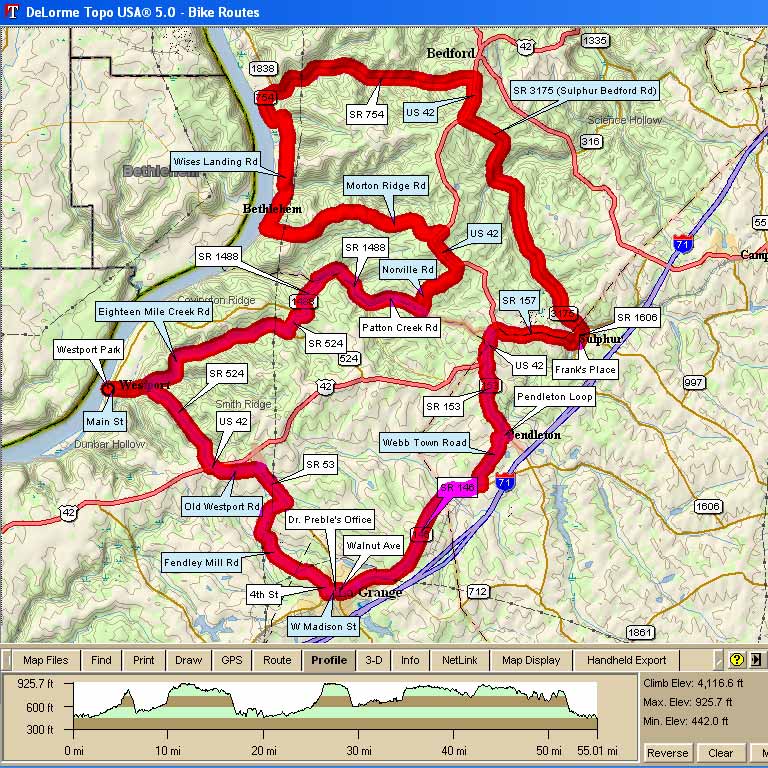
The "Wise Donkey Landing" is an incredibly scenic ride with low or non-existent traffic for much of the route. While a few of the hills may have you climbing like a beast of burden, there is a nice balance of flatlands along river and creek beds.
Along this route, we have seen Red-Tailed Hawks, Blue Heron, Wild Turkey, Red Fox and other critters too numerous to mention.
|
3007 - Gizmo's Wise Donkey Landing |
||
| Miles | Turn | Road |
| 0.0 | Start | Westport Park at Ohio River |
| 0.0 | S | Main St out of park |
| 1.0 | L | Eighteen Mile Creek Rd |
| 5.1 | L | SR 524 |
| 5.6 | R | SR 1488 (Covington Ridge Cutoff) |
| 6.1 | S | Caution: Steep Downhill |
| 6.9 | R | SR 1488 |
| 7.1 | S | Big Brown Dog |
| 8.6 | L | Patton Creek Rd (No Sign) |
| 9.9 | L | Norville Rd |
| 11.5 | L | US 42 |
| 12.5 | L | Morton Ridge Rd |
| 16.6 | S | Caution: Steep Downhill |
| 17.2 | Bear R | Wises Landing Rd, Ohio River on the Left |
| 20.1 | L | to stay on Wises Landing Rd |
| 20.4 | R | SR 754 (Wises Landing Rd) |
| 21.0 | R | SR 754 Trimble County Power Plant |
| 26.6 | R | US 42 |
| 27.6 | L | SR 3175 (Sulphur Bedford Rd) |
| 34.3 | R | SR 1606 |
| 34.4 | Stop | Frank's Place, on the right |
| 34.6 | R | SR 157 |
| 36.7 | L | US 42 |
| 37.5 | L | SR 153, Marathon - Food, no restroom |
| 39.5 | R | Pendleton Loop |
| 39.7 | R | Webbtown Road, Rough RR Tracks |
| 40.6 | X | Rough RR tracks |
| 41.1 | R | SR 146 (Lagrange Rd) |
| 45.7 | R | Walnut Ave |
| 45.8 | L | E Madison St |
| 45.9 | X | SR 53, Becomes W Madison St, |
| 46.1 | R | 4th St |
| 46.8 | S | becomes Fendley Mill Rd |
| 48.0 | S | Caution: Steep Downhill |
| 49.5 | L | SR 53 |
| 50.6 | L | Old Westport Rd |
| 51.7 | L | US 42 |
| 51.8 | R | SR 524 |
| 52.1 | S | Caution: Steep Downhill |
| 55.2 | S | Main St |
| 55.2 | L | Westport Park at Ohio River |
KEY: |
L = Left, R = Right, S = Straight, X = Cross, |
|
 Map Images are copyright © 2004 Delorme, TOPO USA ® and are provided pursuant to their End User Licensing Agreement. Visit http://www.delorme.com for more information.