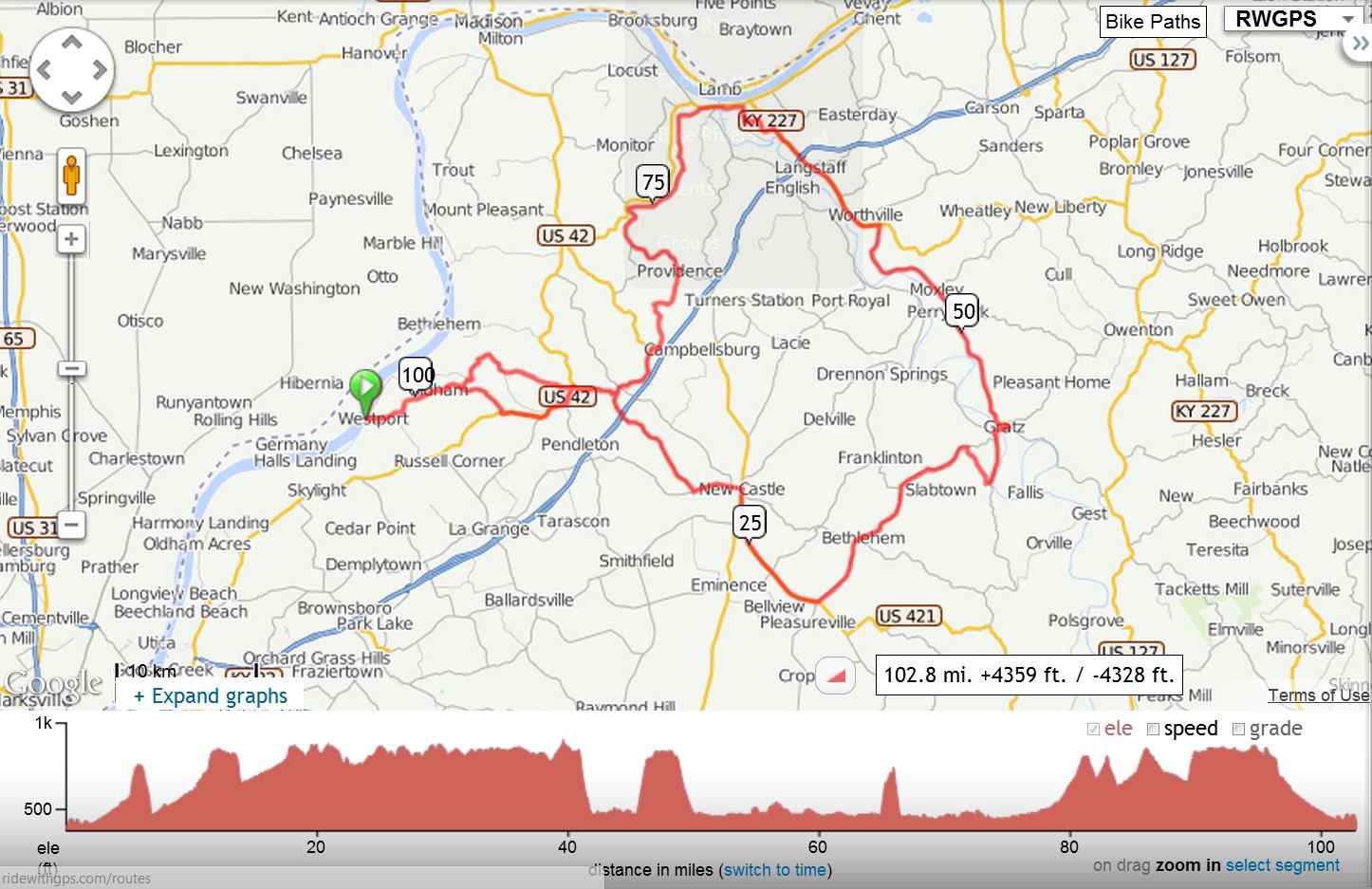
This one, I call General Butler's Assault, and it is a challenging century ride. The route will take us from the little town of Westport, Kentucky through Pleasureville and then down into Lockport. As you hurtle down Leadmine road with a huge grin on your face, just remember to save some energy for the ride ahead.
As you fly through Lockport, take a quick peek at the beautiful Kentucky River as it spills over the dam. The locks are seldom activated these days, but the view is amazing and worth a stop for a snapshot or two.
Next, we cross the Kentucky River at Gratz with an inspiring view from the bridge. You'll need to save some of that inspiration for the rolling hills ahead on Highway 355.
Then, at Carrollton, General Butler awaits. Will you be able to assault the General's hills? Or will the General get the best of you?
Two miles later, the survivors of the assault will rollercoaster down onto Hwy 320 and soon cross the Kentucky River again to begin the journey back.
Enjoy the miles of shady, scenic Carlisle Road, along the river's baby brother, the "Little Kentucky River." It's more like a creek than a river, but a welcome respite after doing battle with General Butler.
We continue our journey through Suphur and Sligo before wending our way back towards Westport.
Visit here: http://www.kybikerides.org/videos/index.htm for a short video of a previous year's assault
3009
- General Butler's Assault
Westport, Sulphur,
New Castle, Lockport, Carrollton
102.9 mi., Elevation Gain:6040, 59 ft/mile
Dr. Larry Preble
Cell: (502) 724-8477 |

|
Miles |
Turn |
Road |
0.0 |
Start |
Westport
Park at
Ohio River |
0.0 |
S |
Main St out of park |
1.0 |
L |
Eighteen Mile Creek Rd |
5.1 |
L |
SR
524 |
5.6 |
R |
SR
1488 (Covington Ridge Cutoff) |
6.1 |
|
Caution: Steep Downhill |
6.9 |
R |
SR
1488 |
8.6 |
L |
Patton Creek Rd (No Sign) |
11.8 |
L |
US
42 |
11.9 |
R |
SR
157 |
14.1 |
R |
SR
1606 (
Rough
Bridge) |
20.2 |
L |
SR
146 |
22.4 |
R |
US
421 |
23.7 |
L |
To
stay on 421 |
29.1 |
L
&
Stop |
SR
22 in Pleasureville (Store: Chevron) |
39.8 |
R |
Leadmine Rd (Watch for it--easy to miss!) |
41.9 |
L |
Main St |
42.0 |
S |
Aces
Chevron - Sunday 12PM to 10PM |
42.0 |
S |
SR
389 (North) Nice View of Lock and
Dam |
44.4 |
R |
SR
22 |
44.7 |
X |
Caution: Cross
Kentucky River |
45.1 |
L |
SR
355 |
45.2 |
R |
To
stay on 355 |
45.3 |
L |
To
stay on 355 |
57.7 |
L |
SR
227 |
62.9 |
S |
Shell,
McDonalds, Burger King, Chevron |
63.6 |
Stop |
Subway in front of WalMart |
|
64.6 |
L |
General Butler Park Rd |

|
66.6 |
R |
SR
320 |
67.3 |
L |
Sycamore
St |
68.2 |
R |
2nd St |
68.3 |
L |
US
42-Caution: Cross
Kentucky River |
68.6 |
S |
Shell
in Prestonville |
69.3 |
L |
Carlisle Road SR 1335 (Not Old
Carlisle!) Little
Kentucky River on the Rt |
78.4 |
L |
SR
316 (up the hill) |
81.5 |
R |
Louden
Lane |
83.9 |
L |
Carmon
Creek Rd |
85.5 |
Bear R |
To stay
on Carmon Creek |
86.2 |
R |
US
421 |
86.4 |
L |
SR
1606 |
89.4 |
R |
SR
157 |
91.5 |
L |
US
42 |
92.3 |
Stop |
Marathon |
92.3 |
S |
Continue
on US 42 |
95.6 |
R |
SR
524 |
97.9 |
L |
Eighteen
Mile Creek Rd |
102.0 |
R |
SR
524 |
102.8 |
S |
Towards
the river |
103.0 |
End |
Westport
Park at
Ohio River |
KEY: |
L = Left, R = Right, S
= Straight, X = Cross, Red = Caution or Stop, Green =sight worth seeing, Blue = Body of Water |
|
Interact with Map or to download GPS File