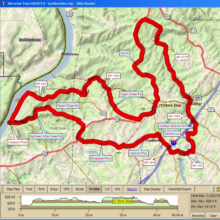
| 3016– Wings 45 Westport, Pendleton, Sulphur, Bedford 46.2 mi, Cumulative Climb: 3100 ft, avg: 67 ft/mile Dr. Larry Preble, Cell: (502) 724-8477 Home: (502) 509-2362 |
||
| Miles | Turn | Road |
| 0.0 | Start | Westport Park at Ohio River |
| 0.0 | S | Main St out of park |
| 1.0 | L | Eighteen Mile Creek Rd |
| 3.1 | R | Rebel Ridge Rd |
| 5.2 | R | Bohannon Ln |
| 6.0 | R | US 42 |
| 6.6 | L | Bluegrass Pkwy |
| 9.4 | L | Old Sligo Rd |
| 9.7 | R | L'Espirit Pkwy |
| 12.1 | R | SR 153 |
| 13.6 | L | SR 146 |
| 15.1 | L | Dawkins Ln |
| 16.3 | R | Wolfpen Branch Rd |
| 17.4 | L | SR 1606 |
| 18.6 | R | X Tracks and Rt turn |
| 18.8 | S | SR 157 |
| 19.1 | L | SR 3175 |
| 25.8 | L | US 42 |
| 33.1 | Stop | Store Stop, then continue US 42 |
| 34.2 | R | Organ Creek Rd |
| 37.1 | S | becomes SR 1488 |
| 38.8 | L | to stay on SR 1488 |
| 40.1 | R | SR 524 |
| 46.0 | R | Main St |
| 46.2 | L | Westport Park at Ohio River |
| KEY: | L = Left, R = Right, S = Straight, X = Cross, Red = Caution or Stop, Green =sight worth seeing, Blue = Body of Water | |
Interact with Map or to Download GPS Route