Out Miles |
Back Miles |
Turn |
4151 - Salem Century Out and Back |
Leg |
0.0 |
98.2 |
R |
out of parking lot onto Market Street |
0.6 |
0.6 |
97.6 |
L |
Spring Street - becomes Hamburg Pike |
6.0 |
6.6 |
91.6 |
R |
US 31 |
3.1 |
9.7 |
88.5 |
R |
SR 31 in Sellersburg |
1.6 |
11.3 |
86.9 |
R |
Weber |
1.6 |
12.9 |
85.3 |
R |
Prather Road |
2.2 |
15.1 |
83.1 |
L |
Stoney Point |
1.0 |
16.1 |
82.1 |
R |
Fox |
0.1 |
16.2 |
82.0 |
L |
Trelor |
1.4 |
17.6 |
80.6 |
R |
Hansberry S onto Murphy Road |
4.3 |
21.9 |
76.3 |
S |
cross Caney Road |
0.8 |
22.7 |
75.5 |
L |
onto SR 160 |
0.2 |
22.9 |
75.3 |
R |
SR 31 Store stop is ahead .20, technically off the route |
1.2 |
24.1 |
74.1 |
L |
Bloomington Trail |
8.8 |
32.9 |
65.3 |
L |
Leota Road |
1.7 |
34.6 |
63.6 |
S |
Up the Hill! |
0.7 |
35.3 |
62.9 |
R |
Saylor Road |
3.6 |
38.9 |
59.3 |
R |
New Philadelphia |
2.2 |
41.1 |
57.1 |
R |
E. Canton |
3.0 |
44.1 |
54.1 |
L |
N. Canton (store) |
0.7 |
44.8 |
53.4 |
R |
Day |
1.7 |
46.5 |
51.7 |
L |
New Heritage |
0.5 |
47.0 |
51.2 |
R |
Old State Road 160 |
2.1 |
49.1 |
R |
around the Town Square in Salem |
||
Retrace the route back |
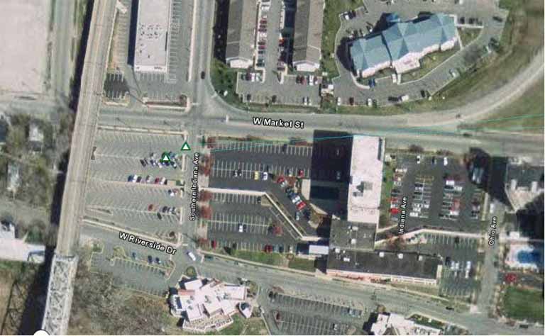
Start: Meet at parking lot beneath the Second Street bridge at the corner of Market Street and Southern Indiana Ave. in Jeffersonville, Ind.