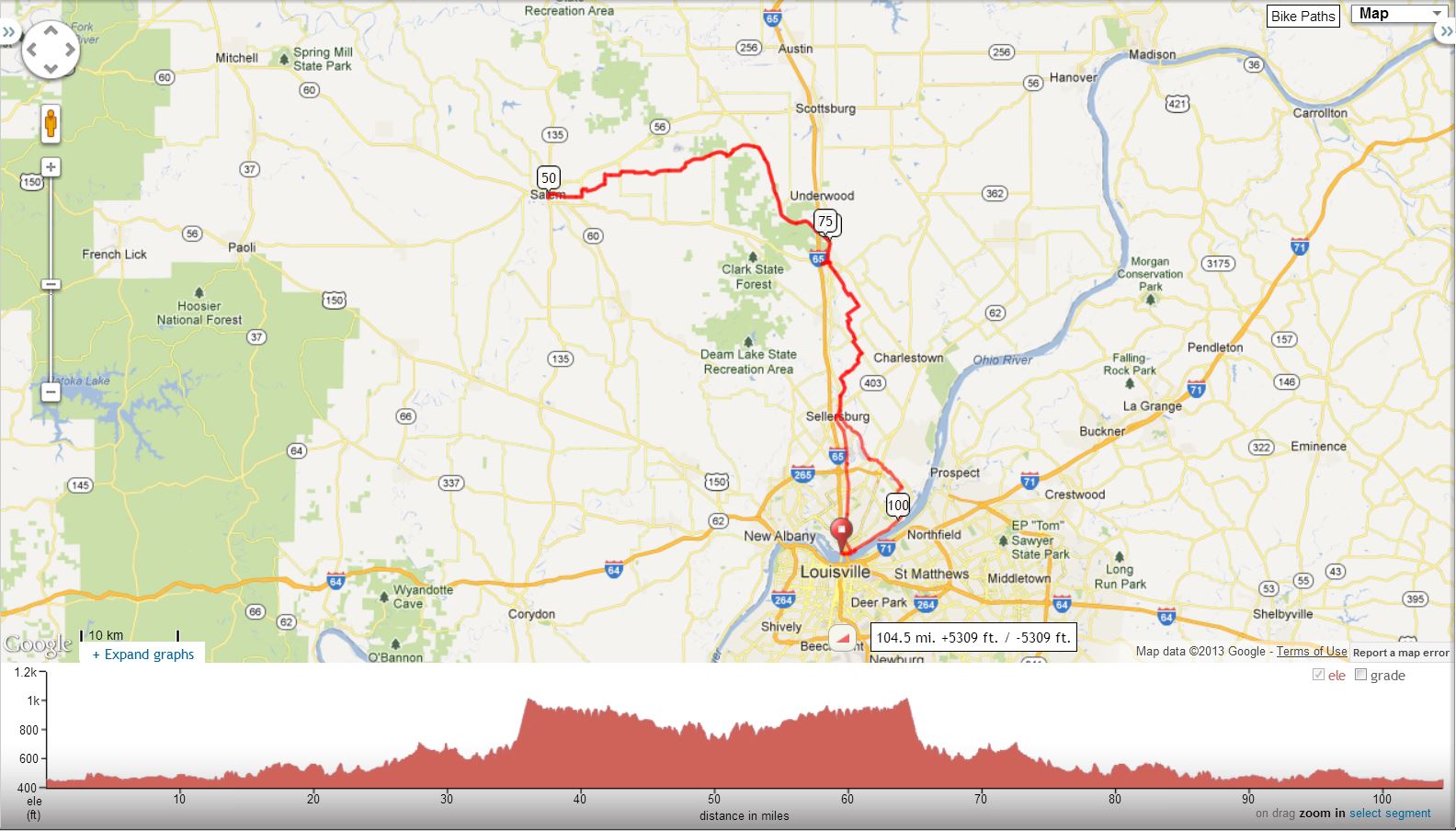
Salem Century, Steve's Version |
||
0.0 |
R |
Out of Parking Lot Onto Market Street |
0.6 |
L |
Spring Street – Becomes Hamburg Pike |
6.6 |
R |
US 31 |
9.5 |
R |
SR 31 in Sellersburg |
11.1 |
R |
Weber |
12.7 |
R |
Brick Church Road |
14.9 |
L |
Stoney Point |
15.9 |
R |
Fox (Easy to Miss) |
16.1 |
L |
Trelor |
17.4 |
R |
Hansberry |
19.5 |
S |
Murphy Road (Do Not Turn Right) |
21.8 |
X |
Caney Road |
22.7 |
L |
SR 160 |
22.9 |
X |
Hwy 31 |
23.1 |
R |
STORE STOP – Marathon-Left Out of Parking Lot Onto SR 160 |
23.3 |
L |
Hwy 31 |
24.5 |
L |
Brownstown (Becomes Bloomington Trail) |
33.4 |
L |
Leota Rd. (BL Past Covered Bridge) |
35.0 |
Up the Hill!!! |
|
35.8 |
R |
Saylor Road |
39.6 |
R |
New Philadelphia |
43.7 |
L |
Franklin Church at “T” (Unmarked) |
43.9 |
BR |
Canton Road |
44.9 |
L |
North Canton (at Grocery Store) |
45.6 |
R |
Day |
47.3 |
L |
Heritage Chapel |
47.8 |
R |
Old 160 (Becomes Market Street) |
50.0 |
R |
Around Salem Town Square to SR 135 Restaurants On SR 135 South Dinner Bell Restaurant* Taco Bell* McDonald's* Subway* KFC* Wendy's - Mileage Turn Around |
51.0 |
R |
Market St. (Becomes Old 160) |
53.3 |
L |
Heritage Chapel |
53.8 |
R |
Day |
55.5 |
L |
North Canton @ “T” (Unmarked) |
56.2 |
R |
Canton at Grocery Store (Unmarked) |
57.2 |
L |
Howell Road |
57.3 |
BR |
New Philadelphia (Unmarked) |
61.3 |
L |
Saylor Road |
64.9 |
L |
N.S. Finley Knob (CAUTION DOWNHILL) |
66.3 |
Becomes Leota Road |
|
67.4 |
BR |
Bloomington Trail (Past Covered Bridge, becomes Brownstown) |
| 71.8 | S | New Chapel Church - Water Spigot at Rear of Building |
76.2 |
R |
Hwy 31 |
77.4 |
R |
Hwy 160 |
77.6 |
R |
STORE STOP - Marathon - Left Out Of Parking Lot Onto SR 160 |
77.9 |
X |
Hwy 31 |
78.2 |
R |
Pennsylvania |
79.0 |
Becomes Prall Hill / Murphy Rd |
|
81.4 |
Becomes Hansberry (Straight) |
|
83.4 |
L |
Trelor (Do Not Go Down Hill!!) |
84.7 |
R |
Fox |
84.9 |
L |
Chas-Memphis Road |
85.5 |
Becomes Stoney Point |
|
85.9 |
R |
Brick Church |
88.0 |
L |
Weber |
89.7 |
L |
Hwy 31 |
90.5 |
L |
Hwy 403 At Traffic Signal |
90.5 |
IMMEDIATE RIGHT New Albany Ave. Before Tracks (Unmarked) |
|
91.1 |
L |
East Utica at 4 Way Stop |
91.6 |
CAUTION – Rough Tracks |
|
92.8 |
Becomes Utica - Sellersburg Pike |
|
94.2 |
CAUTION – Rough Tracks |
|
94.8 |
L |
Coopers Lane |
95.7 |
X |
SR 62 |
96.1 |
L |
New Chapel |
96.2 |
R |
Utica – Sellersburg Pike |
96.6 |
R |
To Stay On Utica – S-Burg Pike |
97.6 |
Becomes Middle Road at Stop Sign |
|
97.9 |
R |
New Middle Road |
98.4 |
L |
Port Road |
99.4 |
R |
Utica Pike |
104.0 |
L |
Walnut Street |
104.1 |
R |
Riverside Drive |
105.0 |
R |
Southern Indiana Ave. (Unmarked) At Rocky's |
105.1 |
L |
Market Street |
105.2 |
R |
Into Parking Lot |
Interact With Map or Download GPS File