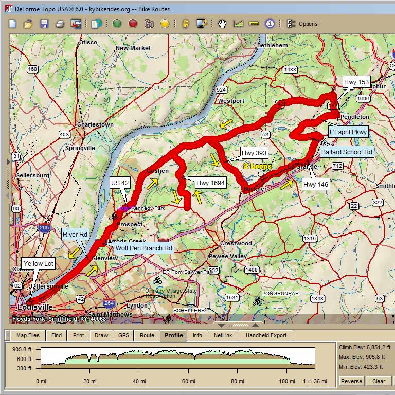
Mad Irondog Century Start at Waterfront Park, Yellow Lot |
||||
Mile |
Turn |
Road |
||
0 |
L |
out of lot on River Rd |
||
7.2 |
BR |
uphill on Wolf Penn Branch Rd |
||
7.8 |
L |
at light on US 42 |
US 42 Caution for traffic merging on/off 265 ramp |
|
9.5 |
S |
continue on US 42 past Prospect Point at River Road |
||
DETOUR ALTERNATIVE |
||||
7.2 |
BL |
to stay on River Rd and cross closed bridge, |
||
7.3 |
lift bike over guardrails |
|||
8.8 |
L |
at light on US 42 to rejoin route at Prospect Point, you will be 0.7 mile short on cue |
||
16.8 |
R |
Hwy 1694 (out and back spur) |
||
21.9 |
U |
U-turn at "T" with Hwy 329 |
329 to return back Hwy 1694 |
|
27 |
R |
US 42 |
||
30.1 |
R |
Hwy 393 |
||
34.9 |
L |
Hwy 146 |
||
34.9 |
L |
Optional Stop at Marathon C-Store |
||
38.4 |
X |
Hwy 53 in LaGrange (Iron Man viewing area) |
||
42.2 |
L |
Ballard School Rd |
||
44.4 |
R |
Old Sligo Rd |
||
46 |
R |
L'Esprit Pkwy |
||
48.3 |
L |
Hwy 153 |
||
49.8 |
L |
US 42 |
||
60.3 |
L |
Hwy 393 to start 2nd loop of IM course |
||
65.1 |
L |
Hwy 146 |
||
65.1 |
R |
Optional Lunch Stop at Subway 100 yards to right |
||
68.6 |
X |
Hwy 53 2nd time thru viewing area again |
||
72.4 |
L |
Ballard School Rd |
||
74.6 |
R |
Old Sligo Rd |
||
76.2 |
R |
L'Esprit Pkwy |
||
78.5 |
L |
Hwy 153 |
||
80 |
L |
US 42 |
||
90.5 |
S |
to continue on 42 back to Louisville |
||
93.2 |
Optional Stop at Skylight Center C-Store |
|||
102.7 |
R |
Wolf Pen Branch Rd |
||
103.3 |
S |
merge with River Rd at stop sign |
||
110.4 |
R |
back into Yellow parking lot |
||
111.8 |
S |
keep going if you're a purist and want go to IM transition area on Great Lawn |
||