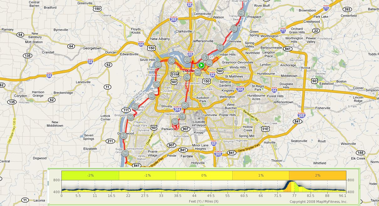
A
Good First Century |
||
Mile |
Turn |
Street |
0.0 |
R |
Exit Parking lot onto River Road |
0.4 |
L |
Witherspoon Way |
0.7 |
L |
N. Clay Street |
0.9 |
R |
E. Main Street |
1.7 |
R |
Onto Clark Memorial Bridge |
2.7 |
R |
Court Avenue |
2.8 |
R |
North Shore Drive |
3.0 |
L |
Southern Indiana Avenue |
3.1 |
L |
West Riverside Drive (at Rocky's) |
4.0 |
L |
Walnut Street |
4.1 |
R |
East Market Street |
4.9 |
|
Market becomes Utica Pike |
10.1 |
S |
Enter Utica |
10.6 |
R |
Market Street (Quarry Bluff sign) |
10.7 |
L |
2nd Street (Quarry Bluff sign) |
10.8 |
R |
North Walnut (Quarry Bluff Sign) |
10.9 |
L |
Upper River Road (Quarry Bluff Sign) |
12.6 |
R |
Longview Beach Road (No Outlet Sign) |
12.7 |
|
Pass CCCC |
13.4 |
U |
At Dead End (7010 Longview Beach Rd.) |
14.2 |
BL |
Upper River Road |
15.9 |
R/L |
to 2nd Street |
16.05 |
R |
at Stop Sign to Market Street |
16.17 |
L |
Utica Pike (North 4th Street) |
|
S |
Utica Pike becomes East Market Street |
22.7 |
L |
Walnut Street |
22.8 |
R |
East Riverside Drive |
24.05 |
on left |
Restrooms and Water Fountain |
|
|
at Ashland Park |
24.64 |
|
Turn around at Falls Of The Ohio |
|
|
State Park (Circular Driveway out front) |
25.59 |
L |
Southern Indiana Avenue (at Rocky's) |
25.7 |
R |
North Shore Drive |
25.8 |
L |
Court Avenue |
25.9 |
L |
Onto Clark Memorial Bridge |
26.9 |
R |
Main Street |
28.1 |
R |
15th Street |
28.45 |
L |
Portland Avenue |
30.17 |
BL |
Northwestern Parkway |
32.1 |
L |
Southwestern Parkway |
32.3 |
R |
Southwestern Parkway |
32.56 |
R |
Into Shawnee Park at River Park Drive |
33.52 |
|
Exit at Broadway |
33.53 |
X |
Broadway and rejoin path on |
|
|
Southwestern Parkway |
35.53 |
R |
Onto 41st Street (41st not marked) |
35.72 |
X |
Bells Lane (Cross traffic does not stop) |
36.37 |
BR |
Campground Road |
39.5 |
R |
Lees Lane |
40.82 |
L |
Levee Trail |
48.5 |
|
Turn around at Farnsley-Moremen Landing |
50.2 |
R |
Five Star Food Mart on Right |
57.24 |
R |
Exit Levee Trail onto Lees Lane |
57.77 |
L |
Campground Road |
60.9 |
BL |
Rejoin Bike Path on L side of street |
61.51 |
X |
Bells Lane (Cross traffic does not stop) |
61.73 |
L |
Algonquin/Southwestern Parkway |
63.72 |
X |
Broadway-enter Shawnee Park |
64.2 |
R |
Exit Shawnee Park |
64.2 |
L |
Southwestern Parkway |
64.48 |
L |
Southwestern Parkway |
64.69 |
R |
Southwestern Parkway |
65.6 |
R |
Bank Street |
68.16 |
R |
16th Street |
68.4 |
L |
Market Street |
69.3 |
R |
6th Street |
71.1 |
L |
Magnolia Avenue |
71.2 |
R |
St. James Court |
|
O |
Fountain in St. James Court |
71.54 |
L |
Gaulbert Avenue |
71.72 |
R |
3rd Street |
75.9 |
S |
enter Iroquois Park |
76.04 |
R |
at Stop Sign (Rundill Road) |
76.32 |
L |
at Stop Sign to Summit (Uphill Road) |
77.84 |
L |
just past Tennis Courts (Tophill Road) |
78.85 |
R |
at basketball court (Uphill Road) |
80.03 |
L |
at bottom of hill (Rundill Road) |
80.24 |
R |
Golf Course Clubhouse on right |
81.64 |
S |
Go around gate at Sanders Gate Road |
83.41 |
X |
New Cut to Southern Parkway |
85.84 |
S |
Southern Parkway turns to 3rd Street |
87.12 |
S |
3rd Street turns to 2nd Street |
89.66 |
R |
Market Street |
90.88 |
L |
Johnson Street (Home of The Innocents) |
90.96 |
R |
East Main Street |
91.36 |
S |
East Main turns to Mellwood Avenue |
93.39 |
X |
Zorn Avenue to stay on Mellwood Avenue |
93.64 |
L |
Mockingbird Valley Road |
93.93 |
L |
River Road |
96.05 |
R |
into Parking Lot |
