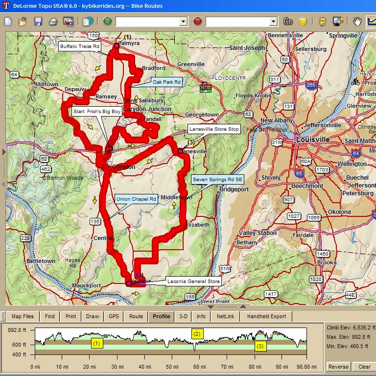
4441 - Big Boy
Century Exit 105 on I-64 in Corydon, IN |
||
Mile |
Turn |
Route |
S |
Start in back lot of Frisch's Big Boy |
|
0.2 |
L |
leave lot via Sky Park |
0.2 |
R |
Hwy 135 |
0.3 |
R |
Old Hwy 135 (watch angled RR crossing) |
2.2 |
R |
back onto Hwy 135 |
2.7 |
R |
Hwy 335 |
3.3 |
R |
Tee Rd |
5.0 |
L |
Zoar Church Rd |
6.9 |
L |
Pfrimmers Chapel Rd |
7.8 |
R |
Crandall-Lanesville Rd |
8.9 |
L |
Angel Run Rd (sharp turn at bottom of hill, Gravel!) |
10.0 |
L |
Crandall Branch Rd |
12.0 |
R |
Hwy 335 (Crandall) |
12.7 |
L |
Motts Rd |
12.7 |
R |
Oak Park Rd |
15.9 |
X |
SR 64 (Caution, busy road!) |
18.0 |
R |
Flatwood Rd |
19.3 |
L |
Farmers LN |
20.5 |
L |
West Bradford Rd |
21.3 |
R |
School Rd |
22.0 |
R |
Gettlefinger Rd (no sign) |
23.0 |
L |
East Rd |
24.6 |
R |
Hwy 135 |
25.8 |
L |
STOP -- Marathon station in Palmyra |
25.8 |
R |
backtrack south on Hwy 135 |
26.6 |
R |
Buffalo Trace (Weilabaker Rd ) |
29.0 |
R |
jog right on Hancock Chapel to stay on Buffalo Trace |
29.1 |
L |
Buffalo Trace |
30.0 |
R |
Wennings Rd (but trust me, your'e still on Buffalo Trace) |
30.8 |
L |
Buffalo Trace |
32.1 |
R |
Flatwood Rd |
32.3 |
L |
Corydon-Ramsey Rd |
32.8 |
R |
Big John Rd (no sign) |
34.1 |
X |
SR 64 (Busy Hwy!) |
34.1 |
S |
Clover Valley Rd |
34.6 |
R |
Fairdale Rd |
35.9 |
L |
Tunnel Hill Rd |
37.4 |
L |
Hwy 337 (Frenchtown) |
43.6 |
L |
Quarry Rd (1/2 century continue straight back to Frischs) |
44.7 |
R |
Corydon-Ramsey Rd |
46.5 |
L |
Hwy 62 (Optional stops At Marathon, BP, or Shell) |
46.6 |
X |
Hwy 135 at light, continue on Hwy 62 to downtown |
47.7 |
R |
N. Capitol Ave. (over bridge and past fairground) |
48.3 |
BR |
uphill to stay on old 135 behind fairgrounds |
51.6 |
L |
Union Chapel Rd |
57.1 |
L |
to stay on Union Chapel Rd at Watson |
59.1 |
R |
Tobacco Landing Rd |
60.8 |
L |
Sycamore |
61.7 |
S |
onto Hwy 11 at stop sign |
62.1 |
Stop -- Laconia General Store |
|
62.1 |
L |
East Laconia Rd |
63.7 |
L |
Kintner Bottoms Rd (no sign) |
66.6 |
R |
Old Goshen RD |
68.6 |
L |
Rehoboth Rd |
69.6 |
X |
Hwy 11 (Busy Hwy!) |
69.6 |
S |
Pumping Station Rd |
70.9 |
R |
Rogers Campground Rd |
74.9 |
L |
Hwy 11 into Elizabeth |
75.0 |
S |
Main St (uphill) |
75.5 |
L |
Main St turns into New Middleton Rd at curve |
75.6 |
R |
Seven Springs Rd |
78.8 |
L |
Black Creek Rd (no sign) |
79.8 |
L |
St. Johns Church Rd |
84.8 |
R |
Hwy 62 (Stop Lanesville Food Mart) bathrooms and water in Lanesville Park further on left) |
84.9 |
R |
Hwy 62 out of Park or Food Mart heading West |
85.2 |
R |
Crandall-Lanesville Rd |
87.2 |
L |
Corydon Ridge Rd |
94.1 |
S |
turns into Walnut St as you enter Corydon |
95.1 |
R |
Old Hwy 135 (redlight at courthouse) |
96.5 |
Bear R |
Hwy 135 to return to Big Boy lot |
97.7 |
Finish! |
|
Map Images are copyright © 2006 Delorme, TOPO USA ® and are provided pursuant to their End User Licensing Agreement. Visit http://www.delorme.com for more information.