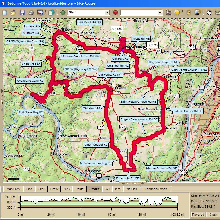
4450 - Shoetree Century Challenge |
||
Mile |
Turn |
Road |
0 |
L |
Start @ 124 Mulberry St. (Harrrison Co Annex lot) Corydon lot) |
0.1 |
R |
Beech St |
0.1 |
L |
Ridley St |
0.3 |
R |
State Hwy 337 |
0.4 |
L |
Capitol (Old Hwy 135 uphill) |
2.3 |
S |
Hwy 135 (stop sign at Shiloh) |
3.8 |
L |
Union Chapel Rd |
9.2 |
L |
to stay on Union Chapel Rd at Watson |
10.2 |
S |
get ready for steep climb |
11.2 |
R |
Tobacco Landing Rd |
12.9 |
L |
Sycamore |
13.8 |
S |
onto Hwy 11 at stop sign |
14.3 |
R |
Store Stop/SAG (Laconia General Store) |
14.3 |
L |
East Laconia Rd |
15.9 |
L |
Kintner Bottom Rd (no sign) |
18.7 |
R |
Old Goshen Rd |
19.2 |
L |
Merk Rd |
20.4 |
L |
Hwy 11 |
20.7 |
R |
Rogers Campground Rd |
27.1 |
L |
Hwy 11 into Elizabeth |
27.5 |
R |
Store Stop (Wilson's General Store) no bathroom |
27.6 |
L |
backtrack Hwy 11 to Fire Station for photo op |
27.6 |
L |
Main St (uphill) |
27.7 |
L |
SAG at Elizabeth EMS Station |
28 |
L |
Elizabeth-New Middletown Rd |
28.1 |
R |
Seven Springs Rd |
31.3 |
L |
Black Creek Rd (no sign) |
32.3 |
L |
St. Johns Church Rd |
37.4 |
R |
Hwy 62 |
37.4 |
L |
Store Stop (Lanesville Food Mart -- no bathroom) |
37.2 |
R |
Hwy 62 |
39 |
L |
St Peter's Church Rd |
39.7 |
L |
SAG at Turtle Run Winery (open 12p to 6p) |
39.7 |
R |
backtrack St. Peter's Church Rd to Hwy) |
40.6 |
L |
Hwy 62 |
40.8 |
R |
Faree Rd |
42.5 |
L |
Ponderosa Rd |
43.3 |
L |
Corydon Ridge Rd |
44.2 |
R |
Big Indian Rd |
44.9 |
R |
Pfrimmer's Chapel Rd (caution! Break in pavement on downhill) |
46.7 |
S |
P-C Rd turns into Crandall-Lanesville Rd |
48.4 |
R |
Hwy 335 |
49.1 |
L |
Motts Rd |
51 |
R |
Oak Park Rd |
52.2 |
X |
Hwy 64 (CAUTION! Busy Hwy) |
52.8 |
L |
Whiskey Run Rd (no sign) |
53.2 |
L |
SAG at New Salisbury EMS Station |
53.3 |
L |
Hwy 135 |
53.9 |
R |
Hwy 64 |
54.0 |
L |
Store Stop (Citgo, Dairy Dip, Village Inn, etc) |
54.1 |
R |
Hwy 135 |
54.4 |
R |
Old SR 64 |
54.5 |
L |
Corydon Junction |
55.7 |
R |
Lost Creek Rd. |
58.5 |
S |
Corydon-Ramsey Rd (64 mile riders turn left here & head south on C-R Rd to rejoin route on Hwy 62 Century riders straight) |
61.8 |
L |
Tunnel Hill Rd |
62.3 |
R |
Hwy 337 |
62.5 |
L |
Milltown-Frenchtown Rd |
65.5 |
L |
Main St (cross bridge over Blue River) |
66.4 |
L |
Lunch Stop at Blue River Café (Milltown Mini-Mart across street) |
66.4 |
L |
First St (uphill next to café) |
66.5 |
L |
Indiana Ave |
S |
turns into South Milltown Rd |
|
68.6 |
L |
Wyandotte Cave Rd |
71.8 |
S |
Shoetree/McFelea Ln (head 1 mile down this road for Shoetree photo op) |
return back up same road to continue on Wyndotte Cave Rd |
||
73.6 |
R |
Wyndotte Cave Rd (Caution! Steep downhill grade/sharp turn/ gravel after Vistor Center |
77.8 |
R |
Hwy 62 |
82.6 |
L |
SAG (Overlook Inn) |
83.3 |
R |
Follow sign down steep hill to "The Dock" |
83.2 |
L |
Court St |
83.6 |
L |
Wood/Wyndotte Ave (Caution! "Cheesegrater" bridge mile 85.6) |
85.7 |
R |
Hwy 62 |
91.3 |
R |
Hwy 462 (hate me later, but get ready to climb now) |
93.6 |
L |
Old Forest Rd |
101 |
R |
Hwy 62 |
102.3 |
S |
Walnut St (past Courthouse on your right) |
102.4 |
R |
Mulberry St |
102.6 |
L |
Annex building lot |
Map Images are copyright © 2006 Delorme, TOPO USA ® and are provided pursuant to their End User Licensing Agreement. Visit http://www.delorme.com for more information.