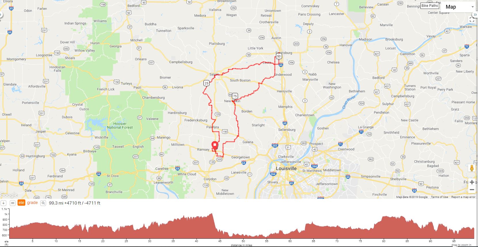
This is the new version of the "Give Me Liberty" Century ride which starts in New Salisbury instead of Crandall. By Cathy Hill
GIVE
ME LIBERTY |
||
Mileage |
Turn |
Route |
0.0 |
R |
Hwy 64 out of parking lot |
0.7 |
R |
Rooster Church Rd |
1.4 |
R |
Whiskey Run Rd NE |
2.3 |
X |
IN-135 S |
2.3 |
S |
E Whiskey Run Rd NE |
2.8 |
L |
Oak Park Rd (Enjoy!) |
4.2 |
R@T |
Flatwood Rd |
5.0 |
L |
School Rd |
6.6 |
R |
Gettlefinger Rd (after sharp left curve) |
7.7 |
L |
Old East Rd |
8.9 |
BR |
@ Stop Sign |
9.3 |
R |
Hwy 135 (Busy) |
10.5 |
X |
Hwy 150 (Busy – Palmyra) |
12.6 |
L |
Palmyra Lake Rd |
13.7 |
R |
Big Springs Rd |
14.4 |
S |
@ SS to stay on Big Springs |
16.2 |
L@T |
To stay on Big Springs |
17.4 |
L@T |
Grandview (no sign) |
18.2 |
R |
Grandview - Straight S Wills Rd |
19.4 |
BL |
S Halo Rd |
20.0 |
L@T |
W. Vincennes Trail |
23.2 |
R |
S Becks Mill Rd |
26.2 |
BR |
W Beck’s Mill Rd |
28.7 |
L |
S Main St |
29.0 |
STOP |
Circle K -Salem (continue on Main St) |
29.3 |
R |
Old State Rd 60 E (by Wendys) |
29.9 |
L |
Fair Street |
30.0 |
R@T |
Market St (Old Hwy 160) |
31.6 |
L@t |
Heritage Chapel Rd |
32.1 |
R |
Day Rd |
33.8 |
L@T |
N Canton Rd (no sign) |
34.4 |
R |
E Canton Rd (Unsigned) @ closed store (Drink Machine) |
35.5 |
BL |
N Howell Rd (Unsigned) |
35.6 |
BR |
New Philadelphia Rd at fork (Unsigned) |
36.5 |
BR/BL |
To stay on New Philadelphia |
39.7 |
L |
E. Saylor Rd |
43.3 |
L |
Leota Rd (caution-downhill) |
45.7 |
S |
Covered Bridge |
45.7 |
BL |
To stay on Leota Rd |
48.0 |
S |
To stay on Leota Rd |
49.1 |
L |
S Lake Road (Co. Rd. 100W) |
51.9 |
R |
Hwy 56 @ light |
52.0 |
LUNCH OPTIONS |
Arbys, McDonald’s, Wendys – Subway @ Walmart in Scottsburg |
52.0 |
L |
Backtrack to Lake Rd @ light |
53.2 |
R |
W Lake Rd |
54.2 |
L |
Boatman Rd/Co Rd 200W |
59.0 |
S |
W Salem Rd @ SS (church on left) (turns into Liberty Knob) |
63.9 |
R |
Hwy 160 |
64.7 |
L |
S Blue River Rd |
69.4 |
BR |
To stay on E Blue River Rd |
E. Blue River Rd continues for another 6 miles with several bear rights to stay on the road |
||
75.7 |
R |
Main St @ Stop Sign |
76.0 |
L |
Shorts Corner Rd/Cross Tracks |
76.1 |
STOP |
Casey’s – Pekin |
76.1 |
-- |
Backtrack across tracks on Shorts Corner Rd |
76.2 |
R |
Main Street (continue across plank bridge (CAUTION) |
77.1 |
L |
Jefferson St |
77.3 |
R |
Voyles Rd |
77.6 |
X |
Hwy 60 (heavy traffic) |
82.0 |
L |
Green Rd (Easy to Miss) |
82.3 |
R |
Green Rd/Pekin Rd (3-way) |
86.5 |
R |
Clark St (1 block before hwy) |
86.8 |
L |
Cross St |
86.9 |
X |
Hwy 150 (Caution) |
86.9 |
S |
Greenville-Georgetown Rd |
88.6 |
R |
Nadorff Rd |
92.0 |
L |
Walk Rd |
93.2 |
X |
Whiskey Rd at Stop Sign |
94.4 |
L |
Hwy 64 (Caution) |
94.7 |
R |
Hwy 335 |
95.6 |
R |
Motts Rd (BR at bottom of hill) |
97.4 |
R |
Oak Park |
98.2 |
L |
Spring Branch Road @ SSS |
98.6 |
R |
Hwy 135 |
99.1 |
L |
Hwy 64 at light |
99.3 |
R |
Parking Lot [END] |
Printer-Friendly Cue Sheet (PDF Format)
Interact with map or Download GPS File