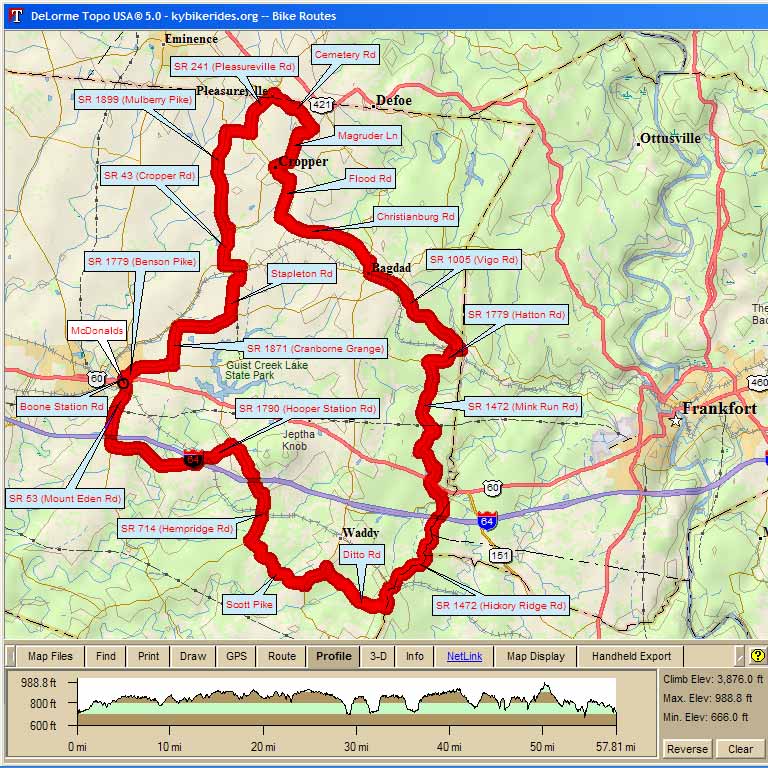
Shelbyville 60 |
||
| Miles | Turn | Road |
| 0.0 | R | US 60 |
| 0.1 | L | |
| 0.2 | R | SR 1779 (Benson Pike) |
| 2.0 | L | SR 1871 (Cranborne Grange) |
| 3.3 | R | SR 1005 ( |
| 5.2 | L | |
| 7.0 | L | SR 12 ( |
| 7.5 | R | SR 43 ( |
| 8.8 | L | |
| 8.9 | R | SR 1899 (Mulberry Pike) |
| 12.2 | R | |
| 13.1 | L | SR 241 ( |
| 14.7 | R | |
| 16.5 | R | Magruder Pike (no sign) |
| 18.0 | R | SR 43 ( |
| 18.5 | L | Flood Rd |
| 20.5 | L | |
| 23.9 | R | SR 395 ( |
| 24.3 | L | SR 12 ( |
| 25.2 | L | SR 1005 ( |
| 25.3 | R | SR 1005 ( |
| Stay on 1005 for the next 3 miles | ||
| 28.6 | R | SR 1779 ( |
| 30.0 | L | SR 1472 ( |
| Stay on 1472 for the next 10 miles | ||
| 40.4 | R | Ditto Rd |
| 43.0 | L | SR 395 ( |
| 44.0 | R | Scott Pike |
| 46.7 | R | SR 714 ( |
| 50.4 | L | SR 1790 ( |
| 54.8 | R | SR 53 ( |
| 56.9 | Finish | McDonalds |
Map Images are copyright © 2006 Delorme, TOPO USA ® and are provided pursuant to their End User Licensing Agreement. Visit http://www.delorme.com for more information.