Pamela Anderson Century 100.0 mi, Cumulative Climb: 7794 ft, avg: 78 ft/mile Start: McDonalds, US 60 in Shelbyville, KY RC: Steve Rice |
|||
Miles |
Leg |
Turn |
Road |
|
Start McDonald's | ||
0.0 |
L |
US 60 |
|
0.5 |
0.5 |
L |
|
0.6 |
0.1 |
R |
|
1.1 |
0.5 |
L |
|
1.2 |
0.1 |
R |
|
2.5 |
1.3 |
L |
Mack Walters / Zaring Mill |
8.2 |
5.7 |
L |
Hwy 148 |
11.4 |
3.2 |
L |
Hwy 44 |
13.4 |
2.0 |
R |
Hwy 44 (Southville) |
14.4 |
1.0 |
L |
|
19.7 |
5.3 |
L |
Hwy 395 |
24.6 |
4.9 |
Store Stop - Waddy Truck Stop |
|
24.6 |
0.0 |
L |
Hwy 395 |
24.6 |
0.0 |
L |
Bardstown Trl |
28.2 |
3.6 |
L |
Ky-1472 |
28.3 |
0.1 |
R |
Old
|
28.7 |
0.4 |
L |
|
28.7 |
0.0 |
R |
US 60 |
28.9 |
0.2 |
BL |
Old US-60 |
30.4 |
1.5 |
L |
Sheep
|
31.4 |
1.0 |
R |
|
33.1 |
1.7 |
L |
|
33.8 |
0.7 |
R |
|
37.4 |
3.6 |
R |
Devils
|
39.0 |
1.6 |
R |
|
39.3 |
0.3 |
L |
US 60 |
39.7 |
0.4 |
R |
Hwy 420 |
40.1 |
0.4 |
L |
To stay on Hwy 420 |
41.7 |
1.6 |
L |
Hwy 676 E (Connector) |
42.4 |
0.7 |
R |
|
43.4 |
1.0 |
R |
|
47.0 |
3.6 |
L |
|
49.6 |
2.6 |
R |
|
50.1 |
0.5 |
L |
US 60 |
50.5 |
0.4 |
LUNCH!!!! KFC |
|
50.5 |
0.0 |
Northwest on US60\421 |
|
51.1 |
0.6 |
L |
Sunset Dr |
51.7 |
0.6 |
R |
|
51.8 |
0.1 |
R |
|
51.8 |
0.0 |
L |
|
52.1 |
0.3 |
L |
Road into Park |
52.4 |
0.3 |
L |
|
52.6 |
0.2 |
R |
Myrtle Ave |
52.8 |
0.2 |
L |
Winding Way Dr |
53.2 |
0.4 |
L |
|
54.6 |
1.4 |
L |
|
54.8 |
0.2 |
R |
US 60 |
55.3 |
0.5 |
R |
|
55.4 |
0.1 |
L |
Browns
|
56.4 |
1.0 |
X |
Cross 127 |
56.5 |
0.1 |
R |
|
56.7 |
0.2 |
L |
Devils
|
60.8 |
4.1 |
R |
|
63.0 |
2.2 |
L |
|
66.6 |
3.6 |
S |
Hwy 12 |
67.3 |
0.7 |
R |
Lebanon Rd |
68.7 |
1.4 |
L |
Catwalk Rd |
70.7 |
2.0 |
R |
Hwy 1922 -Straight onto Jacksonville Radcliff |
73.0 |
2.3 |
S |
Hwy 395 |
76.2 |
3.2 |
Store Stop Bagdad |
|
76.2 |
0.0 |
West on Hwy 12 |
|
76.8 |
0.6 |
R |
Hwy 12 |
78.1 |
1.3 |
R |
Frys-Oldburg Rd |
79.2 |
1.1 |
R |
Christianburg Rd |
79.3 |
0.1 |
L |
Steve Wood Rd |
81.9 |
2.6 |
L |
Hwy 395 |
82.5 |
0.6 |
S |
Hwy 43 (Cropper) |
83.7 |
1.2 |
L |
Magruder Pike |
84.3 |
0.6 |
R |
Ditto Cemetery Rd |
86.1 |
1.8 |
L |
Hwy 241 |
86.2 |
0.1 |
R |
Hill Spring Rd |
87.9 |
1.7 |
L |
Bellview Ln |
88.9 |
1.0 |
L |
Ky-1899 (Mulberry) |
91.5 |
2.6 |
R |
Cropper-Washburn Rd |
94.0 |
2.5 |
R |
Mulberry-Cropper Rd - becomes Bellview |
97.7 |
3.7 |
L |
Turn left onto Hwy 55 |
100.0 |
2.3 |
R |
Turn right onto US 60 |
100.0 |
0.0 |
Finish at McDonald's |
|
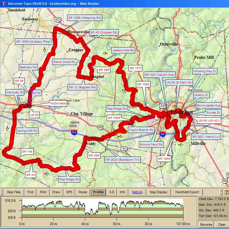
Map Images are copyright © 2006 Delorme, TOPO USA ® and are provided pursuant to their End User Licensing Agreement. Visit http://www.delorme.com for more information.