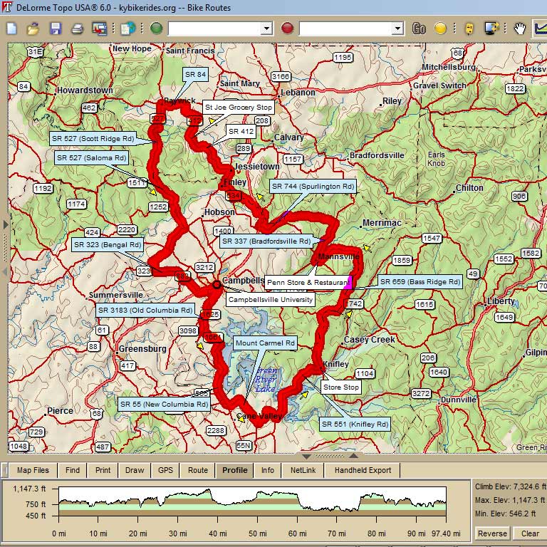
A beautiful tour of south-central Kentucky, going past Green River Lake and on through Taylor, Adair, Casey, and Marion counties. Starts at Campbellsville University.
96.5 Green River Mad Dog Century 96.5 mi, Cumulative Climb: 7325 ft, avg: 76 ft/mile Start: Campbellsville University, Heilman Student Complex Jim "Grizzly" Moore, Cell: (270) 469-6407 |
|||
| Miles | Turn | Road | Leg |
| 0.0 | R | Columbia Av (3183) | 1.8 |
| 1.8 | X | 55 (at SL), continue on 3183 | 2.6 |
| 4.4 | L | 1061 | 0.1 |
| 4.5 | X | 55 (at SS), continue on 1061 |
5.4 |
| 9.9 | L | 55 (at SS), dangerous road! [11.9 into Adair Co] |
2.5 |
| 12.4 | L | 682 (at Coburg) |
0.4 |
| 13.7 | R | to stay on 682 (at SS) | 2.6 |
| 16.3 | L | 2971 (at T) | 1.4 |
| 17.7 | R | West Egypt (turn at bottom of hill) | 1.1 |
| 18.8 | L | 551 (at T, unsigned) [20.5 Cross Green River Lake] |
6.7 |
| 25.5 | STOP | on L: Crossroads Store (in Knifley) | |
| 25.5 | L | 76 | 1.5 |
| 27.0 | R | Eastridge Cemetery Rd |
1.4 |
| 28.4 | L | Roley Yuma Rd (at T) | 0.1 |
| 28.5 | R | Eastridge Cemetery Rd [Into Taylor Co, following the Adair then Casey Co borders for the next 5 miles] |
1.9 |
| 30.4 | R | 1752 (at SS, at water tower, unsigned) | 3.1 |
| 33.5 | X | 70 (at SS), continue on 659 |
4.0 |
| 37.5 | L | to stay on 659 (at church) | 4.0 |
| 41.5 | R | 70 (at T) | 0.3 |
| 41.8 | R | 337 | 0.1 |
| 41.9 | STOP | on R: Penn Store & Restaurant (in Mannsville) | |
| 41.9 | continue east on 337 | 3.7 | |
| 45.6 | L | Barney School Rd [49.4 climb hill, .2 miles, 16-18% grade] | 4.8 |
| 50.4 | R | 744 (at T) [2.4] | |
| 52.8 | R | 208 (just before intersection w/ 68) [53.7 into Marion Co] | 1.4 |
| 54.2 | L | Minnie Brown Rd [back into Taylor Co, then along the Marion Co border for the next 9 miles] |
0.3 |
| 54.5 | X | 68 (at SS), straight on Finley Ridge Rd | 3.1 |
| 57.6 | R | to stay on Finley Ridge Rd (at T) [1.6] | 1.6 |
| 59.2 | R | 289 (at SS, in Finley) [into Marion Co] |
1.7 |
| 60.9 | L | 412 (in Jessietown) | 5.9 |
| 66.8 | STOP | on L: St Joe Grocery | |
| 66.8 | continue north on 412 | 1.4 | |
| 68.2 | L | L Sallie Ray Pk |
1.3 |
| 69.5 | R | Horseshoe Bend Rd (at T) | 0.6 |
| 70.1 | L | 84 (at T) | 2.0 |
| 72.1 | S | to join 527 (in Raywick) | 12.8 |
| 72.3 | S | stay with 527 when 84 turns right |
|
| 74.4 | S | climb Muldraugh Hill, .9 mi, 6-10% gr | |
| 76.1 | Enjoy Horseshoe Bend Overlook | ||
| 79.6 | Enter Taylor Co | ||
| 84.9 | R | 744 (at SS) (in Saloma) | 2.3 |
| 87.2 | X | 210 (at SS), continue on Fallen Timber | 1.9 |
| 89.1 | L | up the hill to stay on Fallen Timber | 0.9 |
| 90.0 | L | 323 | 2.5 |
| 92.5 | R/L | to continue on 323 | 2.0 |
| 94.5 | X | 68 (at SS), continue on Main St | 1.8 |
| 96.3 | L | Columbia Av (3183) | 0.3 |
| 96.5 | L | into Parking Lot at C.U. | |
KEY: |
L = Left, R = Right, S = Straight, X = Cross, Red = Caution or Stop, Green =sight worth seeing, Blue = Body of Water |
||
Click Map to Explore More Features