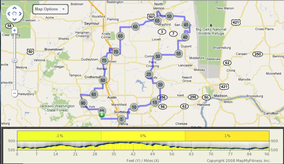
North Vernon Century |
||
0 |
R |
Out of Firehouse crossing St. Rd. 56 |
0.8 |
L |
Lake Road West |
4 |
S |
Lake Road West (SS) |
5 |
X |
St. Rd. 31/becomes Lover's Lane |
6.7 |
L |
Double or Nothing (150E) (SS) |
8 |
X |
St. Rd. 56 to Slate Cut Road (SS) |
8.7 |
R |
Grain Bin Road (50N) |
9.5 |
L |
New Frankfort Rd. |
10 |
R |
Blocher Road (100N) |
11.1 |
X |
St. Rd. 203 (SS) |
13.2 |
L |
at T (No sign. Blocher Rd. 550E) |
14.3 |
L |
St. Rd. 3 (SS) |
14.7 |
R |
Polk Road (AKA North Street) |
16.8 |
L |
1233 W |
17.9 |
X |
St. Rd. 256 to 1250 (SS) |
20.8 |
L |
Blake Road (SS) |
22.3 |
R |
St. Rd. 3 (SS) |
23.3 |
L |
Deputy Pike/Main Street |
24.2 |
R |
N 1500 |
25.3 |
S |
Dixon Ford (250) |
28.1 |
X |
St. Rd. 250 to 200W/Tate |
29.9 |
L |
Byfield (Town of Commiskey) |
30.1 |
R |
Jennings STORE STOP |
L |
Out of store |
|
R |
850/Main |
|
30.8 |
X |
St. Rd. 3 to 115W (SS) |
31.6 |
R |
800S (Becomes 900N) |
35.9 |
L |
Jake Gayle Road |
38.9 |
R |
500S (SS) |
39 |
X |
State Road 7 |
40.3 |
L |
500E/Becomes 300/500/325 |
43.7 |
L |
600E/Grayford |
45.7 |
L |
150E/Grayford |
46.6 |
R |
500E |
48.2 |
L |
20N (T) |
51.3 |
L |
25N |
52.4 |
L |
40N |
53.4 |
R |
St. Rd. 7/3 |
54.8 |
R |
St. Rd. 50 |
54.9 |
L |
Pfat Guy Bar and Grill (LUNCH) |
R |
Out of store on 50 |
|
55.1 |
X |
St. Rd. 3/7 |
55.3 |
L |
Norris |
57.2 |
R |
60S/becomes70/350/130 |
60.9 |
R |
150S/becomes200/215 |
63.8 |
L |
200S (NO SIGN) |
66.2 |
L |
900 W |
72 |
R |
Commiskey Pike |
74.6 |
L |
St. Rd. 31 |
75.6 |
R |
50S |
76.1 |
L |
1125E (SS) becomes 1100 |
77.1 |
R |
125 S |
77.5 |
L |
1060 |
78.3 |
R |
200S/becomes1025 |
79.1 |
X |
St. Rd. 250 |
80.7 |
L |
400S (SS) |
80.9 |
R |
St. Rd. 31 (SS) |
82.2 |
L |
Into STORE (FAST STOP) |
L |
out of store to continue on 31 |
|
83 |
R |
Main Street |
83.4 |
L |
Bethany (SS) becomes 1025 |
85.4 |
R |
800S/becomes 850E |
88.9 |
R |
St. Rd. 256 (SS) |
91.8 |
L |
St. Rd. 39 (SS) |
94.2 |
L |
to continue on 39 (SS) |
95.8 |
L |
Washington/becomes Little York |
98.6 |
R |
Finley Firehouse Road |
99.8 |
R |
Parking lot of Firehouse |
Map Images are copyright © 2006 Delorme, TOPO USA ® and are provided pursuant to their End User Licensing Agreement. Visit http://www.delorme.com for more information.