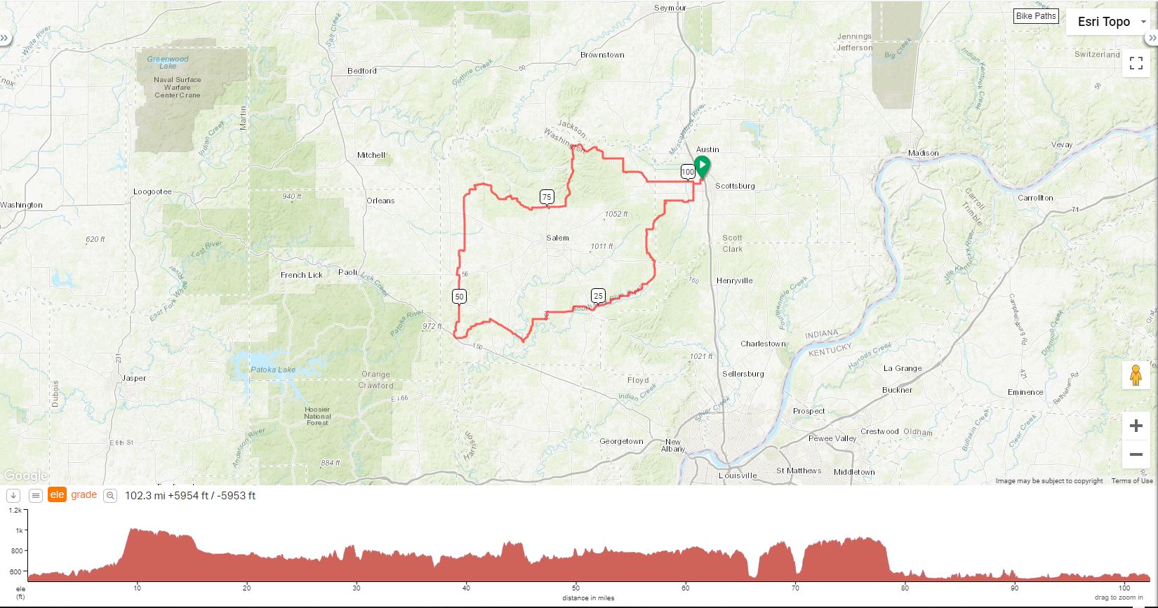
Modified Hardinsburg Century |
||
0.2 |
L |
Wilson Road (Cty. Rd. 125 W) |
0.7 |
R |
Weir Road (first road on right) |
1.4 |
L |
S. Boatman Road |
2.3 |
X |
State Road 56 |
3.2 |
R |
W. Lake Road (Cty. Rd. 150 S) |
6.5 |
L |
Zion/S. Bloomington Trail |
6.8 |
R |
Stage Coach (cty. Rd. 500W) |
8.0 |
R |
Leota Road (prepare for first climb) |
9.4 |
S |
N. New Salem Finley (Top of Hill) |
11.0 |
BL |
New Salem Finley |
11.4 |
S |
New Salem Finley |
13.5 |
L |
Blue River Road |
15.4 |
X |
St. Rd. 160 to continue on Blue River |
20.2 |
L |
to stay on Blue River |
20.3 |
R |
to stay on Blue River |
21.2 |
L |
to stay on Blue River |
21.5 |
R |
to stay on Blue River |
24.1 |
R |
to stay on Blue River |
26.3 |
R |
Main Street |
27.1 |
L |
Shorts Corner Rd. (no sign) |
27.1 |
X |
State Road 60 *CASEY'S STORE STOP (Rt) |
R |
Out of store to continue on Short's Corner |
|
27.6 |
L |
Shorts Corner Rd. (no sign) |
30.0 |
S |
to continue on Shorts Corner |
31.7 |
L |
OLD State Road 135 |
32.2 |
L |
State Road 135 |
32.4 |
R |
Big Springs Road/Grand View |
33.2 |
S |
Grand View |
33.9 |
L |
Horner's Chapel |
35.2 |
BR |
Horner's Chapel |
36.8 |
R |
Mt. Carmel |
41.3 |
L |
W. Kansas Church |
41.4 |
L |
SW Washington School Road |
41.6 |
R |
Kay's Chapel |
42.5 |
R |
H-Burg/becomes Sinking Creek ROUGH PAVEMENT |
46.4 |
R |
State Road 150 |
46.5 |
R |
Wells Street |
46.5 |
L |
Wells Street (Becomes Bear Cat) |
46.7 |
R |
N. Livonia/Hardinsburg Road |
48.7 |
L |
To stay on Livonia/H-Burg |
51.1 |
L |
Posey Chapel |
51.2 |
BR |
Livonia/Hardinsburg Road |
53.7 |
DUTCH BARN LUNCH STOP ON RIGHT |
|
53.7 |
L |
St. Rd. 56: LITTLE TWIRL LUNCH STOP past next turn on R |
53.9 |
R |
North Street (DON'T MAKE TURN IF EATING Little Twirl) |
56.7 |
R |
Mt. Taber |
57.3 |
L |
Campbellsburg/Livonia Road |
61.3 |
X |
St. Rd. 60 to Sycamore/White River (BathRoom on right) |
63.7 |
R |
To stay on White River |
64.4 |
L |
To stay on White River |
64.6 |
L |
To stay on White River |
65.4 |
R |
Prowsville Rd |
67.4 |
R |
to continue on Prowsville |
70.5 |
R |
Highland |
73.4 |
L |
Water Treatment/Becomes Pump Station |
75.6 |
R |
St. Rd. 135 |
75.7 |
R |
Jeanette Road (RED BARN BAIT ON Right) |
L |
out of store (way you came) |
|
75.8 |
L |
St. Rd. 135 |
75.9 |
R |
Delaney Park Rd. |
80.4 |
R |
E. Jackson |
80.5 |
L |
Delaney Park Rd. |
82.2 |
Delaney Park Bathroom Op. |
|
85.2 |
S |
Mt. Eden Road (no sign) |
87.9 |
R |
to continue on Mt. Eden |
91.6 |
R |
Garriot Road |
93.0 |
S |
Pumpkin Center/Short Cut Road |
93.1 |
L |
Power Line Road |
94.6 |
S |
St. Rd. 39 |
96.2 |
L |
E. Washington/becomes Little York |
101.0 |
R |
Boatman Rd. |
101.3 |
L |
Weir Road |
102.1 |
L |
Wilson Road (Cty. Rd. 125 W) |
102.5 |
R |
Community Way |
L |
Into Parking Lot |
|
Download Printer-Friendly Cue Sheet Here
Interact with map or Download GPS File