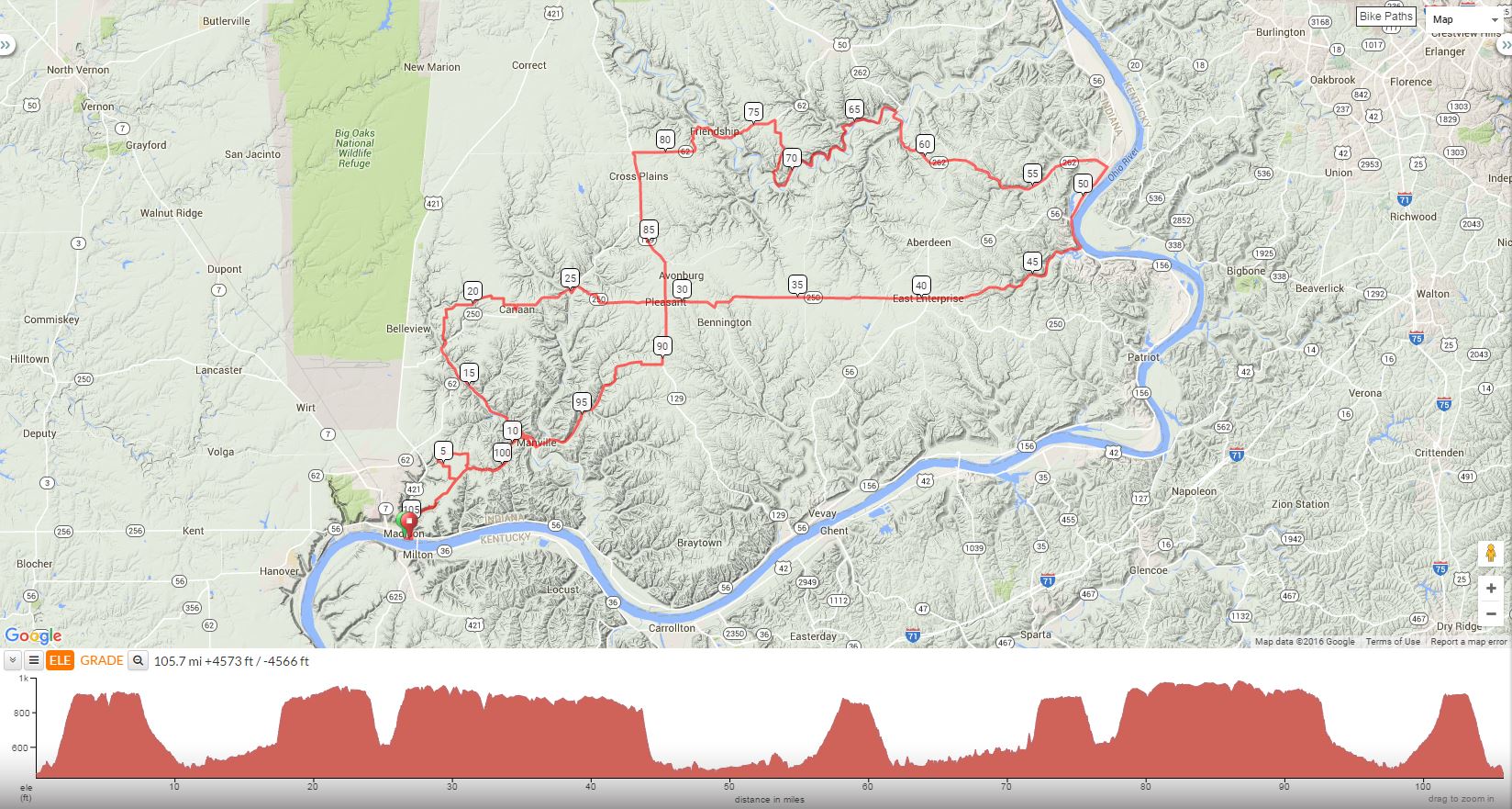
Start at Bicentennial Park, Vaughn dr, Madison, IN 47250
2016 Tour de Indiana, ver. 1; TMD; Madison, IN RCMichael Crawford; 502.314.9977 |
||
Mile |
Turn |
Road |
0.0 |
L |
Vaughn from Centennial Parking Areas |
0.3 |
L |
East |
1.1 |
R |
Aulenbach |
(Aulenbach becomes Dugan Hollow Hill) |
||
3.1 |
L |
Bear L Rykers Ridge |
3.8 |
L |
K |
5.2 |
R |
Old St. Rd. 62 |
5.6 |
R |
Cross |
6.7 |
R |
300 E |
7.3 |
L |
Wolf Run (SCENIC) |
11.0 |
BL |
@ intersection X the Bridge |
11.2 |
L |
China-Manville |
15.5 |
R |
62 E |
17.0 |
R |
250/62 |
17.4 |
L |
Copeland Ridge |
19.9 |
L |
Copeland Ridge @ T Stop |
20.3 |
R |
Slight R 925 |
21.5 |
R |
Flatbottom |
21.7 |
L |
900 |
(900 Becomes Canaan Main St.) |
||
22.3 |
L |
Canaan Main Cross (easy to miss) |
22.4 |
L |
250/62 |
22.5 |
BR |
250/62 |
25.5 |
R |
250 East |
29.3 |
X |
129 (CAUTION) (STORE STOP ON R) |
R |
from Store 250 E |
|
35.4 |
(STORE STOP ON L(Fairview Grocery-Picnic Tables) |
|
L |
From Store 250 E |
|
38.2 |
Just past E Enterprise—Store Stop L |
|
41.0 |
L |
Slight L Red Hog Pike(SCENIC) |
44.4 |
BR |
Becomes Lower/Upper Grants Creek |
46.4 |
(CAUTION 1 LANE BRIDGE) |
|
46.6 |
BR |
Becomes North Landing Rd. |
47.7 |
L |
56/156 (Ohio River Scenic Hwy)(CAUTION SINGLE FILE) (HWY 56 WILL BECOME WALNUT ST. IN RISING SUN) |
51.5 |
R |
Main St. (MULTIPLE LUNCH options including “Courtyard on the River” Note: Main is one way South |
52.1 |
Take Main to 262 West-Stay On 262 |
|
62.8 |
L |
Laughery Creek (SCENIC) |
65.6 |
L |
Stay on Laughery Creek towards Bells Branch |
70.9 |
R |
Bells Branch |
71.8 |
BL |
Stay on Bells Branch |
73.4 |
BL |
Stay on Bells Branch |
74.1 |
L |
62 W (Sunset Drive) |
77.0 |
Stay on 62 |
|
77.9 |
L |
Main in Friendship (STORE STOP) Note: just before 77.9 there are restrooms left over a little bridge across from the shooting range with water spigot. |
82.0 |
L |
129/62 (9 Mi. of chip seal follows) |
83.1 |
STORE STOP ON L (Otters-No Restroom) |
|
88.8 |
STORE STOP ON L @ Intersection of 129/250 |
|
90.2 |
R |
Caledonia (SCENIC) |
90.4 |
BR |
@ Y @ church to stay on Caledonia |
92.3 |
L |
East Tate Ridge (SCENIC) |
93.4 |
L |
N Brushy Fork(Scenic-Caution Downhill-Gravel at Bottom) |
97.6 |
R |
China-Manville |
97.7 |
L |
Immediate L X Bridge (N Crum) |
97.9 |
R |
East Wolf Run (SCENIC) |
101.6 |
S |
@ 4-way intersection to (Rykers Ridge) |
102.8 |
R |
Dugan Hollow Hill becomes Aulenbach-Caution downhill |
104.0 |
L |
East |
104.5 |
R |
Moody Park Lane (easy to miss) |
104.7 |
L |
Walnut (CAUTION MAKING TURN) |
105.2 |
R |
Vaughn |
105.8 |
R |
Centennial Parking Areas |
Download Printer-Friendly Cue Sheet
Interact with Map or to download GPS Route