|
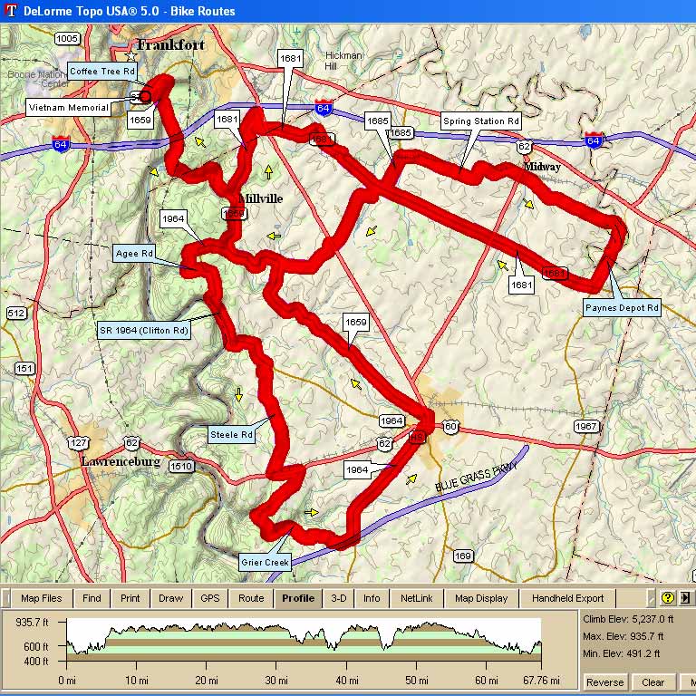
70 miles; Spring in the Bluegrass 5237 Cumulative Climb, 75 ft/mile average climb RC Michael Crawford (cell #314.9977) |
||
| 0.0 | R | out of parking lot on to 1784 (Coffee Tree Rd.) |
| 0.8 | R | @ stop sign on to Glenn's Creek Rd.(1659 S);caution single file downhill |
| 5.3 | L | on to 1681 (before the bridge-no sign) |
| 7.6 | R | on to Hoover Blvd. (industrial park) |
| 8.2 | S | across Versailles Rd./US 60 on to 1681 east-caution |
| 9.6 | S | across the RR tracks |
| 12.0 | L | on to 1685 |
| 13.0 | S | across the RR tracks |
| 13.0 | R | after crossing RR tracks on to Spring Station Road |
| 16.6 | S | @ stop sign across South Winter St. (use caution) |
| 19.6 | R | bear right @ Y on to Paynes Depot |
| 21.3 | R | @ the T stop sign on to 1681 (no sign-church on the right) |
| 23.9 | 43 milers-Wallace Station Restaurant on R (restroom/lunch-great food) | |
| 24.3 | S | @ 4 way stop across HW 62 (use caution) |
| 27.9 | L | on to 1685 |
| 29.9 | S | @ the stop sign across US:60 (caution) |
| 30.8 | L | bear left @ Y & stay on 1685 south |
| 31.9 | R | @ the stop sign on to 1659 north (no sign) |
| 33.7 | Caution watch for gravel @ end of downhill curving left | |
| 34.5 | 70 milers L in to Woodford Reserve Distillery Visitor Center-lunch | |
| 35.4 | L | on to 1694 (follow "70 out" pavement mark) |
| 37.1 | L | @ stop sign on to Hipee Agee |
| 37.5 | R | @ the T stop sign on to 1964 (no sign) |
| 38.4 | Begin descent CAUTION U TURN LEFT AT ROCK WALL; AFTER THIS TURN GREAT FAST STRAIGHT DOWNHILL! | |
| 39.9 | L | @ T stop sign on to 1694 (no sign) |
| 41.3 | R | on to Steele Rd. (no sign) |
| 44.4 | S | across RR tracks; then turn left |
| 44.5 | L | @ T stop sign on to 62 (single file use caution) |
| 45.1 | R | on to Shyrock's Ferry (New Hope Church on right) |
| 46.1 | caution on the downhill; watch for u TURN LEFT at the bottom | |
| 46.8 | L | on to Grier's Creek Rd |
| 48.7 | L | @ T stop sign on Scotts Ferry/1694 (no sign) |
| 50.0 | L | @ T stop sign on to McGowan's Ferry (no sign) |
| RIDE SINGLE FILE THE NEXT 4 MILES INTO VERSAILLES | ||
| 52.4 | S | @ the stop light across HWY 2113 |
| 53.5 | R | @ the T stop sign on to Rose Hill Avenue(caution Versailles traffic) |
| 53.6 | L | @ the 1st stop light onto South Main St. (use caution) |
| 53.7 | S | thru stop light across Lexington St. |
| 53.9 | L | @ the stop light onto 1659 north (use caution) |
| 58.4 | stay on 1659; follow "70 in" pavement mark | |
| 68.2 | L | @ top of the hill on to Coffee Tree Rd./1784 |
| 69.9 | L | into parking Lot |
 Map Images are copyright © 2006 Delorme, TOPO USA ® and are provided pursuant to their End User Licensing Agreement. Visit http://www.delorme.com for more information.