Challenging but scenic Century ride from Carefree, Indiana through Alton, Buzzard's Roost, Derby, Cannelton, Tell City and beyond.
(Cue Sheet and GPS file updated 08/04/2016.)
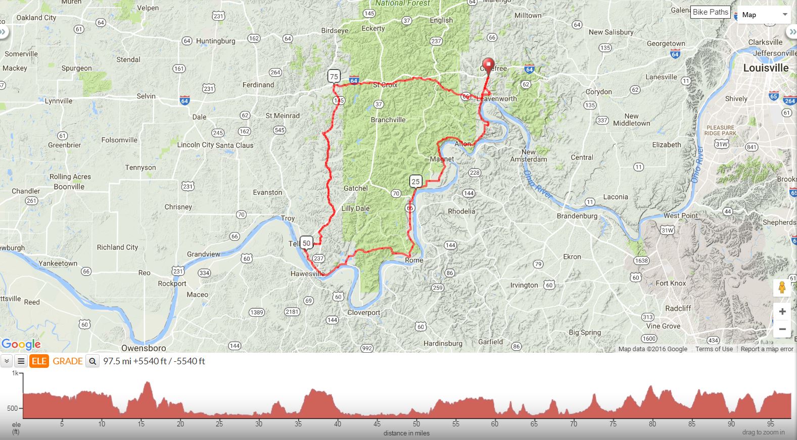
Carefree Century
98 Miles, Climb 5541 Feet
Pilot Travel Center, Carefree, IN, I-64, Exit 92
Mile |
Turn |
Road |
0 |
R |
out of parking lot on Hwy 66 |
1.4 |
BL |
TSO 66 |
2.5 |
R |
Hwy 62W/66 |
3.7 |
BL |
Fredonia Rd |
5.1 |
BR |
at curve (Alton/Fredonia Rd) |
7.3 |
BR |
at curve - scenic overlook on left |
7.5 |
R |
South Cape Sandy Ridge |
7.8 |
R |
TSO South Cape Sandy Ridge |
9.2 |
S |
Continue onto South Alton Fredonia Rd |
12.1 |
WALK bike across Alton Bridge |
|
13 |
L |
at fork on Buzzards Roost (easy to miss) |
15.5 |
L |
at T to stay on Buzzards Roost |
CAUTION: steep downhill to stop sign |
||
18.5 |
L/R |
at T, Immediate Right on Dexter Magnet Rd |
22.4 |
S |
at stop sign to merge on Hwy 66 West |
24.8 |
Construction - 1 lane bridge with stoplight |
|
25.8 |
STOP |
Derby General Store on right - single restroom, others across hwy at Mulzer Park |
42.1 |
L |
at Stop Sign, to continue on Hwy 66 |
42.7 |
Optional Stop - Rocky Point Waterfront Grill - |
|
43.32 |
R |
to continue on Hwy 66 |
47.7 |
X |
Hwy 237 at light |
49.5 |
STOP |
Subway, Sonic, KFC/Taco Bell, McDonald's, DQ, Arby's, Wendy's |
50.4 |
R |
14th St (before Long John Silvers) |
51 |
R |
Mozart Street |
52.7 |
S |
at Stop Sign to merge on Hwy 68 |
52.9 |
L |
Old SR 237 (before 237) |
53.9 |
L |
SR 237 (busy) |
54.5 |
R |
Old SR 37 |
56.6 |
X |
SR 37 (busy) |
57.8 |
L |
Hwy 145 at Stop Sign |
75 |
R |
Hwy 62E |
81.1 |
X |
SR 37 |
81.2 |
STOP |
Marathon on left |
81.3 |
L |
out of parking lot on 62E |
95 |
L |
Indian Ridge Rd |
96.1 |
S |
to merge on Hwy 66 |
97.7 |
L |
back into Pilot Lot |
S=Straight X=Cross BL=Bear Left BR=Bear Right TSO=To Stay |
||
Printer friendly Cue Sheet (pdf format)
Interact with map or download GPS file
Map Images are copyright © 2006 Delorme, TOPO USA ® and are
provided pursuant to their End User Licensing Agreement. Visit http://www.delorme.com for more information.