Map Images are copyright © 2006 Delorme, TOPO USA ® and are provided pursuant to their End User Licensing Agreement. Visit http://www.delorme.com for more information.
700 - Crestwood Killer Century
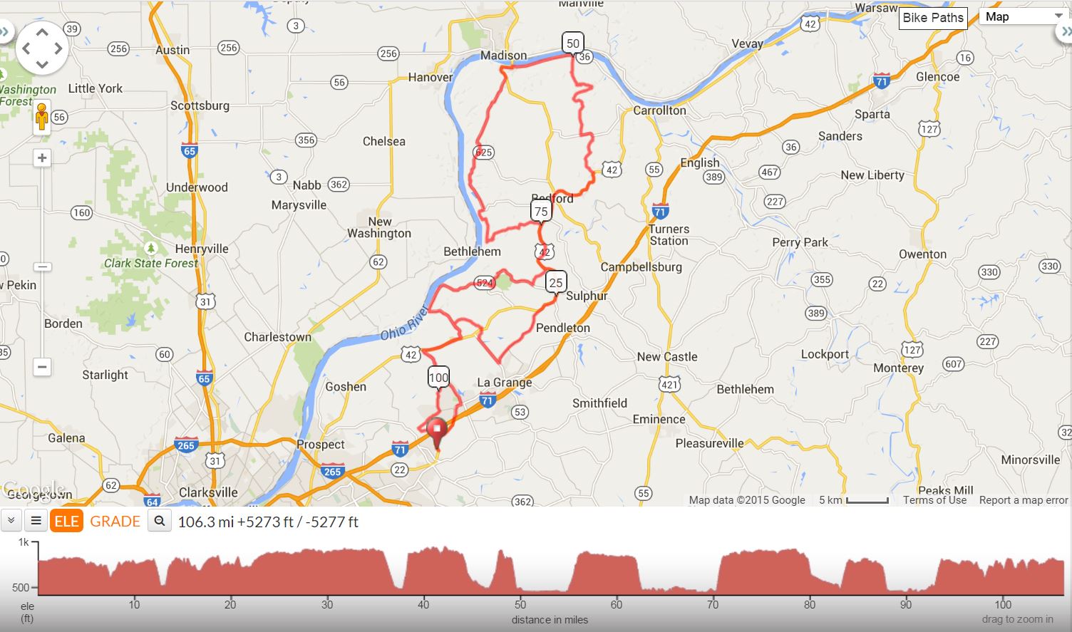
It was the toughest century of the year but with perhaps the most spectacular views. Bill Pustow captained one of Rory's old rides from the nineties. For a while, this ride was a yearly regular, long before the Mad Dogs got their names. The Crestwood killer features seven major step climbs of up to 500 feet putting the OKHT Pottershop Century to shame. The route took us through Oldham, Henry, Trimble and Carroll counties with a stop in Milton, KY for lunch. This was the last "Tour de Mad Dog" century of the season; so, the group also passed the traditional Hot Pickle for tasting at the Bray Orchard store stop. This century came with great vistas, hard work, and a tremendous feeling of accomplishment as riders from age 28 to age 73 tackled the climbs.
700 - Crestwood Killer Century |
||
Miles |
Turn |
Road |
0 |
Start |
Crestwood Station |
0 |
R |
Out of Parking lot onto 146 |
0 |
L |
North Camden Ln |
0.2 |
L |
Old Lagrange Rd |
2.6 |
L |
over RR Tracks and right onto 146 |
3.2 |
R |
over RR Tracks and left onto Old LaGrange Rd |
3.9 |
R |
146 OLD CEDAR POINT RD |
4.2 |
L |
393 @ light |
9.1 |
R |
42 |
12 |
L |
524 |
13.2 |
R |
Smith Ln (FIRST CLIMB) |
15.5 |
X |
42 onto 18 Mile Church Rd |
16.1 |
Bear R |
Old Westport Rd (RIGHT @ Y ) |
16.3 |
L |
53 |
18.6 |
L |
3223 (Old Sligo Rd) |
23.3 |
R |
42 |
33.7 |
Stop |
Bedford Store Stop (MARATHON) |
33.6 |
Bear R |
to stay on 42 |
38 |
L |
3176 (Bells Ridge Rd) |
41.3 |
L |
1226 |
42.2 |
R |
1477 (Culls Ridge Rd / west prong of Locust Creek Rd) |
CAUTION: Rough, narrow, gravelly, winding down hill NO SHOULDER!!! |
||
46.9 |
L |
Fairview Rdg |
48 |
L |
1492 (Fairview Rdg) @ SS/red barn |
48.2 |
R |
Hunter Heights Rd |
50.6 |
L |
36 @ SS |
55 |
L |
36 @ SS |
55.1 |
Stop |
Milton Store Stop |
55.2 |
S |
421 to go up the hill |
56.7 |
R |
625 (Mt Pleasant Rd) STEEP DOWNHILL SS AT END!!!! |
62.5 |
R |
1838 CORN CREEK RD |
67.3 |
R |
754 |
67.4 |
L |
Wises Landing Rd |
70.2 |
L |
Gills Ridge Rd (CLIMB) |
72.9 |
R |
BRAY'S RIDGE RD |
74.9 |
Stop |
Bray's Orchard Store Stop on left (LAST STORE STOP) |
74.9 |
R |
US 42 |
78.6 |
R |
Norville Rd |
80.2 |
R |
SR 1488 (Patton Creek Rd) |
81.7 |
R |
1488 @ SS |
83.2 |
L |
to stay on 1488 and climb hill |
84.6 |
S |
524 |
90.5 |
L |
Westport (NO STORES) |
93.8 |
R |
42 |
96.7 |
L |
393 |
99.3 |
R |
Cedar Point Rd |
101.6 |
R |
Old Zaring Rd |
103.6 |
L |
Glenarm Rd |
105.4 |
R |
146 |
106.4 |
R |
into Crestwood Station |
Printer friendly two-sided cue sheet in PDF format
Interact with Map or to Download GPS Route
Map Images are copyright © 2006 Delorme, TOPO USA ® and are provided pursuant to their End User Licensing Agreement. Visit http://www.delorme.com for more information.